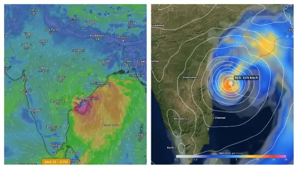
Bhubaneswar: Odisha and neighbouring coastal Andhra Pradesh are bracing for severe weather as the low-pressure area that formed over the east-central and adjoining southeast Bay of Bengal early on Friday is expected to intensify into a cyclonic storm and track northwestward.
According to recent updates from meteorological models including the Global Forecast System (GFS) and the European Centre for Medium-Range Weather Forecasts (ECMWF), alongside official bulletins from the India Meteorological Department (IMD) in Bhubaneswar, the system is projected to intensify into a cyclonic storm by the morning of October 26. The weather models show broad agreement on a west-northwestward track. Visualisations on platforms such as Windy.com indicate the system intensifying off the Andhra Pradesh coast by afternoon of October 27, with the centre projected near Kakinada–Visakhapatnam stretch by around 3 pm on October 28, pointing to a possible landfall just south of Visakhapatnam rather than a direct hit on the city.
Cyclone formation Alert in Bay of Bengal!
Track & Intensity prediction by ECMWF model https://t.co/MJq7x1amwX
— Odisha Weatherman (@OdishaWeather7) October 23, 2026
Some model guidance also raises the possibility of the system reaching severe cyclonic storm intensity, though official forecasts currently describe it as a cyclonic storm that will continue to strengthen.
Coastal districts of north Andhra Pradesh and south Odisha are under close watch for strong winds, rough seas and heavy rainfall. Squally conditions with winds of 35–45 kmph gusting to 55 kmph are already affecting parts of the Bay, expected to rise to 45–55 kmph gusting to 65 kmph on October 24 and 50–60 kmph gusting to 70 kmph on October 25. Gale-force winds of 70–80 kmph gusting to 90 kmph are forecast over the west-central Bay from the morning of October 26. Squally winds of 40–50 kmph gusting to 60 kmph are likely along and off the Odisha–Andhra Pradesh coasts from October 27, intensifying further through October 28.
Sea conditions will deteriorate from rough to very high over the west-central Bay between October 26 and 28.
Rainfall is expected to resume in Odisha from October 27. Red warnings for extremely heavy rainfall exceeding 20 cm has been issued at isolated places in Puri, Ganjam, and Gajapati starting late October 27, and extending into Rayagada, Koraput, and Malkangiri by October 28, while broader areas of coastal and interior Odisha have been placed under orange and yellow warnings for heavy rain, thunderstorms and gusty winds in the coming days.
Also Read: October Fury Returns: Red Alert In Odisha, Stirring Memories Of Historic Super Cyclone, Phailin
Fishermen have been advised to return to shore by the morning of October 24 and not to venture into the east-central, west-central and northwest Bay of Bengal or along the Odisha–Andhra Pradesh coasts until at least October 28.
Potential impacts include damage to standing crops and plantations, uprooting of trees, disruption to power and communication lines, localised flooding and waterlogging, and interruptions to road, rail and marine transport. Residents in vulnerable areas have been urged to stay indoors during peak conditions, secure loose structures and follow official advisories.