
Bhubaneswar: The very severe cyclonic storm ‘Arnab’ weakened after making landfall in Andhra Pradesh, unleashing very heavy rain in several parts of south Odisha on Wednesday.
According to India Meteorological Department (IMD), cyclone Arnab weakened into a severe cyclonic storm at 8.30 am following completion of its landfall process.
The system is likely to move north-north-westwards during next 48 hours and weaken gradually. It will weaken into a cyclonic storm during next six hours and further into a deep depression during subsequent six hours, the weather agency said.
Cyclone Arnab crossed the Andhra Pradesh and Yanam coasts to the southwest of Yanam, about 20 km east-northeast of Narsapur, 40 km Southwest of Yanam and 60 km southwest of Kakinada during 2 am and 8 am as a very severe cyclonic storm with a maximum sustained wind speed of125-135 kmph gusting to 150 kmph.
The latest observations indicate that the landfall process has been completed with the central region moving completely into land.
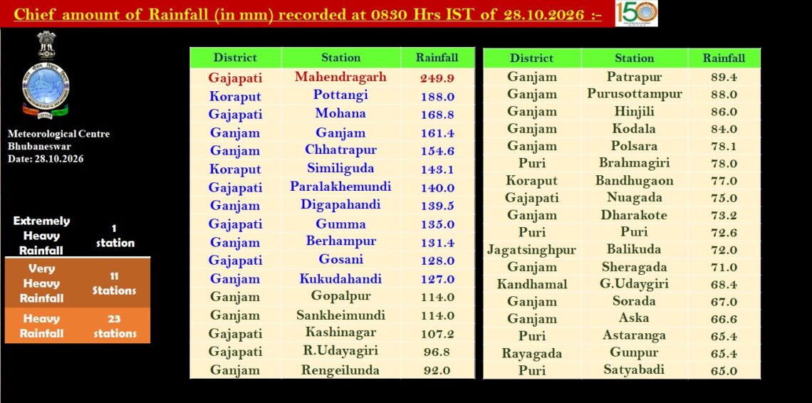
Under the influence of the cyclone, several districts of Odisha, including Koraput, Gajapati, Ganjam, Nabarangpur and Malkangiri were battered by heavy to extremely heavy rain since Tuesday.
According to IMD data, Koraput recorded rainfall of 188 mm, while Ganjam recorded 161 mm and Gajapati 135 mm.
Following intense rain, several districts in south Odisha face the risk of flash floods, according to Director of Bhubaneswar Regional Meteorological Centre Manorama Mohanty.
Malkangiri, Koraput, Rayagada, Ganjam and Gajapati are among the districts facing the threat of flash floods. Heavy rainfall associated with the cyclone may trigger sudden flooding in vulnerable areas.
According to IMD sources, squally winds with speeds of 40-50 kmph, gusting to 60 kmph, are prevailing over the region. Wind speeds are expected to intensify from the forenoon of October 28, reaching 60-70 kmph with gusts up to 80 kmph over the southern districts of Odisha.
The gale-force winds are likely to continue until the night of October 28. Thereafter, wind speeds are expected to remain in the range of 50-60 kmph, with gusts reaching 70 kmph, until the morning of October 29, before gradually weakening.
The districts likely to experience strong winds include Ganjam, Gajapati, Nabarangpur, Rayagada, Koraput and Malkangiri.
The IMD’s warning indicates that southern Odisha could face a combination of strong winds and flash flood risks during the period of heightened cyclone activity.
The cyclone’s impact has been felt across several districts of south Odisha, including Malkangiri, Gajapati, Ganjam, Koraput, Nabarangpur and Rayagada.
Chief amount of Rainfall (in mm) recorded at 8.30 am on Wednesday:

The state administration is maintaining regular contact with district officials to monitor the situation and ensure public safety. Efforts are focused on protecting people and minimising possible damage.
Revenue and Disaster Management Minister Pujari said no reports of major damage had been received so far. The administration continues to monitor the evolving weather conditions and take necessary precautionary measures.