
Bhubaneswar: The severe cyclonic storm was about 150 km southeast of Paradip (Odisha), 180 km south-southeast of Dhamara (Odisha) and 250 km south of Sagar Island (West Bengal) at 2.30 pm.
It is expected to move north-northwestwards and cross north Odisha and West Bengal coasts between Puri and Sagar Island close to Bhitarkanika and Dhamra (Odisha) during midnight and Friday morning with a wind speed of 100-110 kmph gusting 120 kmph, according to the India Meteorological Department.
The landfall is mostly a slow process, which usually takes around 5-6 hours.
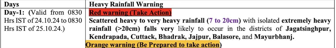
The weather agency has also forecast light to moderate rainfall at most places with heavy to very heavy rainfall at a few places and extremely heavy rainfall (≥ 21 cm) at isolated places in Balasore, Mayurbhanj, Bhadrak, Kendrapada, Jagatsingpur Keonjhar, Jajpur, Cuttack and Dhenkanal, Khurda and Puri districts on October 24.25.
Moderate to rain/thundershower with one or two spells of intense rain and surface wind speed reaching 35-40 kmph may occur in some parts of Bhadrak, Kendrapada, Jagatsinghpur, Cuttack (including Cuttack city), Khurda (including Bhubaneswar) and Puri districts by 7.30 pm on Thursday.


Also Read: Odisha Receives Heavy Rain As Cyclone ‘Dana’ Barrels Towards Coast; IMD Issues Red Message
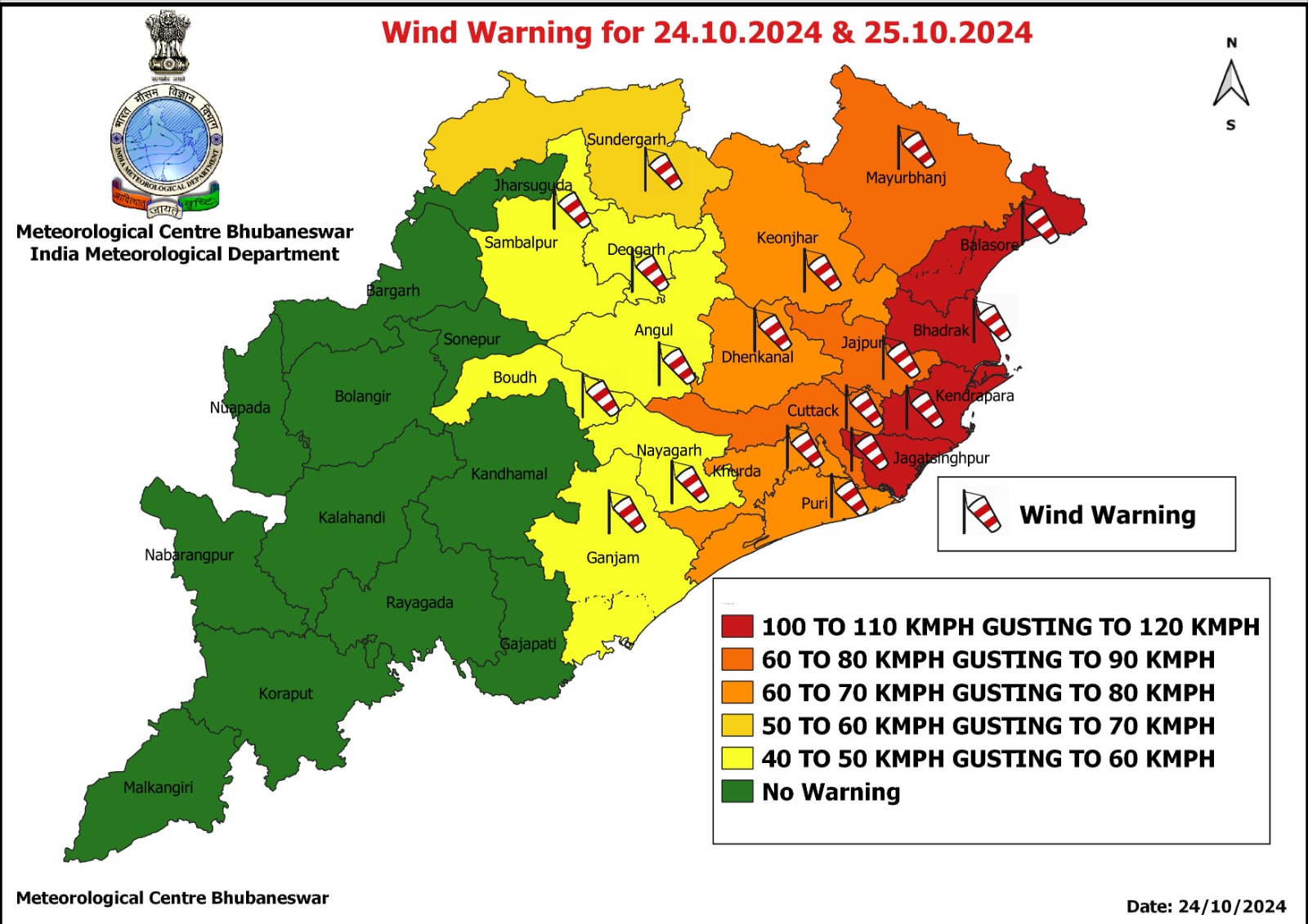
The weather agency has also issued wind warning for different districts of Odisha on these two days.
Kendrapada, Jagatsinghpur, Bhadrak and Balasore are in high-risk zones with wind velocity of 100-110 kmph, gusting to 120 kmph. Mayurbhanj along with Jajapur and Cuttack is in the second category with wind speeds of 60-70 kmph, gusting to 80 kmph.
Similarly, the districts of Puri, Khurda, Dhenkanal and Keonjhar may experience wind speed of 60-70 kmph, gusting to 80 kmph while it will be 50-60 kmph, gusting
to 70 kmph in Sundargarh district.
Also Read: Cyclone ‘Dana’: 40 Flights From Bhubaneswar Affected, Over 200 Trains Cancelled
In Bhubaneswar, wind speed may increase slowly and peak by tonight. “Severe cyclonic storm Dana is in the north-west adjoining central Bay of Bengal and it is moving towards north-northwestward at a speed of 13 kmph in the last six hours. It will make landfall between midnight of today to the early morning of the morning of October 25 as a severe cyclonic storm while crossing wind speed will be around 100 to 110 kmph… In the capital city, heavy rainfall is expected and wind speed will slowly increase and the highest wind speed is likely to occur tonight,” said Bhubaneswar Meteorological Centre director Manorama Mohanty.
The severe cyclonic storm is likely to re-curve slightly towards west and west-southwards after landfall, triggering rain in southern Odisha around October 26, she added.

The IMD has prohibited all marine activities, including fishing, in the Bay of Bengal until the cyclone has passed.
According to Centre for Environment and Climate (CEC) of Siksha ‘O’ Anusandhan Deemed to be University (SOA) here, the cyclonic storm may move in a north-westerly direction and cross the Odisha coast close to Rajnagar in Kendrapada district this evening.
The landfall may happen three hours earlier than the time anticipated or three hours afterwards, it said.
The wind speed at the time of landfall is likely to be around 100 kmph and it will mostly impact Kendrapada, Bhadrak, Jajpur and Mayurbhanj districts.
The CEC bulletin said the eye of the storm was visible in the Doppler Radar at Paradip for an hour or two but subsequently it was not very prominent. Due to high pressure in upper atmosphere called blocking high, the system will move south-westwards instead of north-westwards after crossing the coast near Rajnagar.
A blocking high pressure system, also known as blocking anticyclone, is a large scale slow-moving area of high pressure which can prevent other pressure systems from moving into an area.
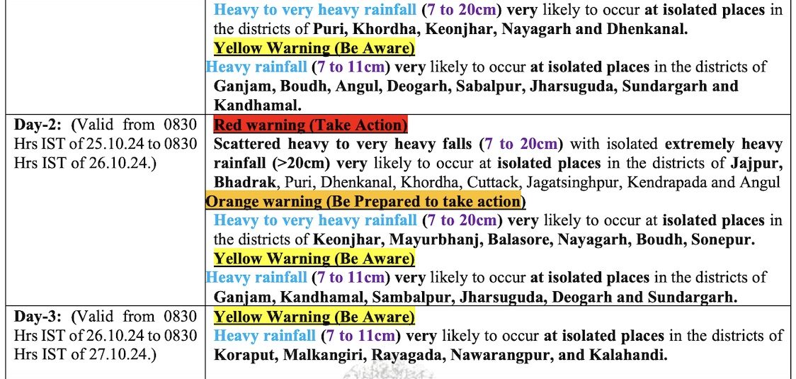
Heavy rainfall accompanied by varying wind speed ranging from 45 to 60 kmph is expected to commence late tonight or Friday morning in the districts of Jajpur, Bhadrak, Kendrapada, Cuttack, Dhenkanal, Angul, Khurda, Jagatsinghpur, Nayagarh, Kandhamal, Kalahandi, Nuapada, Nabarangpur and Koraput and continue till October 26. It will, however, depend on its movement through these districts, the bulletin added.