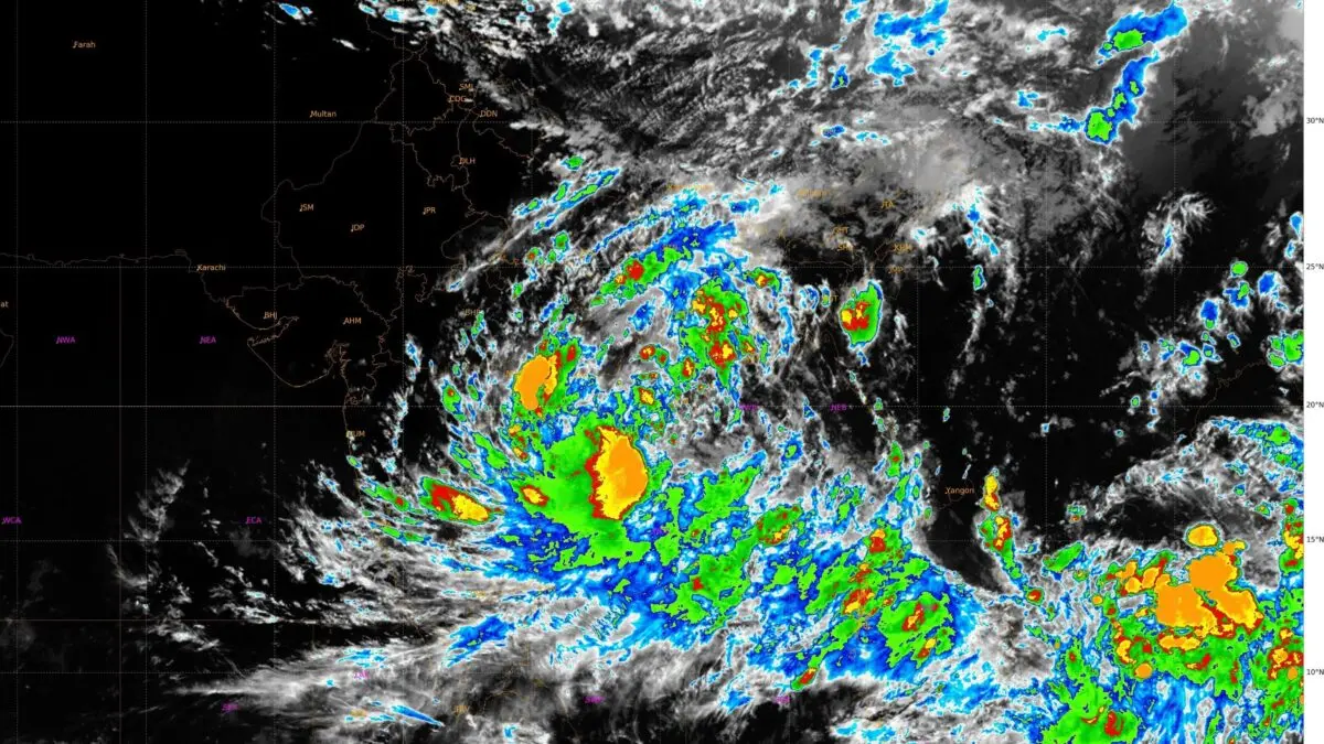
Bhubaneswar: A deep depression over westcentral & adjoining Northwest Bay of Bengal is set to cross North Andhra Pradesh and adjoining South Odisha coasts within the next 2 hours, the India Meteorological Department (IMD) informed on Wednesday evening.
Moving slowly in a west-northwest direction at a speed of 6 kmph, the weather system is centered roughly 30 km south-southwest of Kalingapatnam in Andhra Pradesh and 160 km southwest of Gopalpur in Odisha.
According to the national forecaster, the system is likely to continue to move west-northwestwards and cross the coastline close to Kalingapatnam between Visakhapatnam and Gopalpur before midnight, retaining its intensity as a deep depression with sustained wind speeds ranging from 55 to 65 kmph and gusts reaching up to 75 kmph, rather than escalating into a full-fledged cyclonic storm. The tracking visualisation highlights the broad cloud band and strong wind field moving directly over northern coastal Andhra Pradesh and southern Odisha.
The approaching landfall has already triggered torrential rains across several coastal and adjoining districts. Heavy to very heavy rainfall, accompanied by gusty winds ranging from 50 to 60 kmph and extending up to 75 kmph, is battering Srikakulam, Vizianagaram, Visakhapatnam, and parts of southern Odisha.
The IMD has issued a red alert for Kalahandi, Nabarangpur, Koraput and Malkangiri, forecasting heavy to very heavy rainfall with extremely heavy falls at isolated places. Orange alerts covered several other southern and coastal districts, while yellow warnings applied to parts of northern Odisha. The red warning continues for Nabarangpur on Thursday. Squally winds gusting up to 75 kmph are expected along and off the South Odisha-North Andhra Pradesh coasts through Thursday evening.
Odisha’s Preparedness
The Odisha government has mobilised emergency apparatus across vulnerable southern districts. District administrations in Ganjam, Gajapati, Rayagada, Koraput, and Malkangiri have been put on maximum alert, with heavy downpours already triggering localised waterlogging and heightened risks of flash floods and landslides in hilly areas.
Precautionary evacuations have commenced in vulnerable low-lying regions as well, directing residents to operational cyclone shelters equipped with essential supplies. At least 5,000 people, including 3,500 in landslide-prone Gajapati district, have been shifted to cyclone shelters and temporary relief camps, where cooked food is being provided.
The Gajapati administration has also closed major tourist attractions and waterfalls, including Mahendragiri, BN Palace, Paralakhemundi and nine waterfalls such as Gandahati and Budubuda, until further notice. Khordha, Jagatsinghpur, Ganjam, Gajapati, Kalahandi, Koraput, Puri, Rayagada and Balangir district administrations have announced the closure of schools for the day, while schools in Malkangiri will remain closed until September 24. Anganwadi centres will also remain closed till September 24. Government employees’ leave has also been cancelled in Ganjam, Koraput and Kalahandi, and teachers in districts like Koraput and Kalahandi have been directed to remain at their postings until September 25.
Local Warning Signal Number 3 has been hoisted at all ports, accompanied by a strict ban on fishing activities along the Odisha and West Bengal coasts through Friday.
Earlier in the day, Chief Minister Mohan Charan Majhi held a review meeting and directed officials to maintain the highest level of preparedness with a focus on ensuring “zero casualty”. A total of 33 Odisha Disaster Rapid Action Force (ODRAF) teams have been deployed across affected districts, while nine additional teams have been kept on standby at Chhatrapur.
Met officials added that the system will move further inland post-landfall, gradually weakening into a depression by Thursday.