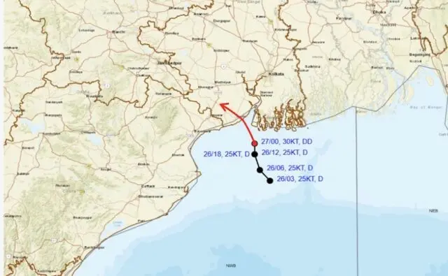
Bhubaneswar: The Depression over northwest Bay of Bengal and adjoining areas of North Odisha-West Bengal coasts intensified into Deep Depression on Monday.
The system moved very slowly northwards with the speed of 3 kmph during the past 6 hours, intensified into a deep depression and lay centred at 5.30 am over northwest Bay of Bengal and adjoining areas of West Bengal-North Odisha coasts,, about 40 km south of Sagar Island (West Bengal), 70 km east-southeast of Digha (West Bengal), 100 km south of Diamond Harbour (West Bengal), 120 km east-southeast of Balasore (Odisha) and 120 km south-southwest of Canning (west Bengal).
It is likely to move nearly north-northwestwards and cross West Bengal-north Odisha coasts between Baleshwar and Canning around afternoon, according to the India Meteorological Department (IMD).
Under the influence of the system, heavy to very heavy rainfall may occur at a few places with extremely heavy rainfall at isolated places in Odisha on July 27, isolated heavy to very heavy rainfall on July 28 and heavy rainfall from July 29-August 1.
The Met office has issued a red warning for districts of Sundaragada, Kendujhar and Mayurbhanj on July 27.
Heavy to very heavy rainfall may also occur at a few places in Baleshwar, Bhadrak, Jajpur, Kendrapada, Jagatsinghpur, Kataka, Jharsuguda, Baragada, Sambalpur, Debagada, Anugola, Dhenkanal, Sonpur, Boudh, Kandhamala, Nuapada, Nabarangpur, Balangir, Kalahandi and Kandhamala.
Heavy rainfall is likely at a few places in Nuapada, Balangir, Kalahandi, Nabarangpur, Rayagada, Koraput, Malkangiri, Gajapati, Ganjam, Puri, Khordha and Nayagada.
Squally winds with speed reaching 50-60 kmph gusting to 70 kmph may prevail over North Bay of Bengal & adjoining Odisha-West Bengal-north Andhra Pradesh coasts till the morning of July 28 and decrease gradually thereafter. Squally winds with speed reaching 40-50 gusting to 60 kmph are also likely over central and northeast Bay of Bengal during this period.
With incessant rains lashing Odisha for the last two days after a low pressure system intensified into a depression, the IMD has also issued a low to moderate flash flood risk warning for Anugola, Boudh, Baragada, Debagada, Kendrapada, Kendujhar, Bhadrak, Kataka, Kendrapada, Jagatsinghpur, Dhenkanal, Rayagada, Sambalpur, Sonpur and Sudaragada districts. The weather system dumped heavy rainfall of 192 mm at Banki in Kataka district in the last 24 hours ending at 8.30 am on Monday, followed by Athagada in the same district at 174 mm, Sonpur at 135 mm and Kendrapada at 133 mm.
Meanwhile, floodwaters released from the Hirakud Dam have submerged low-lying regions in Tirtol and Kujang, stranding nearly 200 families and severely damaging local paddy and vegetable crops.