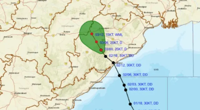
Bhubaneswar: The deep depression over south Odisha weakened into a depression on Friday and moved into interior parts of the state, triggering widespread rain.
The India Meteorological Department (IMD) said that the deep depression moved north-north-westwards with a speed of 10 kmph during past six hours and weakened into a depression.
The depression lay centred over interior Odisha about 40 km south-southwest of Phulbani, 100 km east-northeast of Bhawanipatna, 140 km south of Sambalpur and 190 km south of Jharsuguda.
It is very likely to move north-north-westwards across interior Odisha and weaken gradually into a well-marked low pressure during next 12 hours, the weather agency said.
On Friday, heavy to very heavy rainfall accompanied by thunderstorm/lightning and gusty surface wind speed reaching 30-40 kmph may continue in Sundargarh district.
Isolated heavy rainfall along with thunderstorm/lightning and gusty surface wind speed reaching 30-40 kmph is also likely in Keonjhar, Mayurbhanj, Jharsuguda and Bargarh.
Thunderstorm/lightning and gusty surface wind speed reaching 30-40 kmph may also occur in Puri, Khurda, Nayagarh, Ganjam, Gajapati,Sonepur, Boudh, Nuapada, Balangir, Kalahandi, Kandhamal, Nabarangpur, Rayagada, Koraput, Malkangiri, Balasore, Bhadrak, Jajpur, Kendrapada, Cuttack, Jagatsinghpur, Sambalpur, Deogarh, Angul and Dhenkanal, it added.