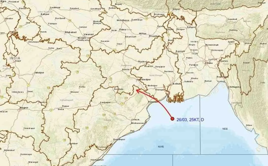
Bhubaneswar: Severe rain warning continues for Odisha as well-marked low-pressure area over northwest Bay of Bengal and adjoining areas of North Odisha-West Bengal coasts concentrates into a Depression over the same region.
The system was about 130 km south-southeast of Sagar Island (West Bengal), 140 km southeast of Digha (West Bengal), 170 km east of Chandbali (Odisha) and 180 km east-southeast of Balasore (Odisha) at 8.30 am on July 26. “It is very likely to move northwestwards, intensify further into a deep depression during the next 24 hours and cross north Odisha and West Bengal coasts between Paradip and Sagar Island around forenoon/noon of July 27,” the India Meteorological Department (IMD) informed on Sunday in its midday bulletin.
The Weather agency has issued red warning for nine districts for two days along with orange and yellow warnings for several parts of the state. Severe weather conditions may lead to river swelling, localized flooding, and waterlogging in low-lying areas and underpasses. Residents should also prepare for reduced visibility, landslides, and potential damage to vulnerable structures, unpaved roads, and standing crops.
July 26
Red Warning: Heavy to very heavy rainfall may occur at a few places with extremely heavy rainfall at one or two places in the districts of Jajpur, Kendrapada, Jagatsinghpur, Kataka, Anugola, Dhenkanal.
Orange Warning: Heavy to very heavy rainfall is also likely at a few places in Baleshwar, Bhadrak, Sundaragada, Jharsuguda, Baragada, Sambalpur, Debagada, Kendujhar, Mayurbhanj, Kalahandi, Kandhamala, Sonpur, Boudh, Nuapada, Balangir, Puri, Khordha and Nayagada.
Thunderstorm accompanied by lightning and gusty surface wind (40-50 kmph) is likely at one or two places in Baleshwar, Bhadrak, Jajpur, Kendrapada, Jagatsinghpur, Kataka, Anugola, Dhenkanal, Kendujhar and Mayurbhanj.
Yellow warning: Heavy rainfall may also occur at a few places in Nabarangpur, Rayagada, Koraput, Malkangiri, Gajapati and Ganjam.
Thunderstorm accompanied by lightning and gusty surface wind (30-40 kmph) is also likely at one or two places over in Sundaragada, Jharsuguda, Baragada, Sambalpur, Debagada, Sonpur, Boudh, Nuapada, Balangir, Kalahandi, Kandhamala, Nabarangpur, Rayagada, Koraput, Malkangiri, Gajapati, Ganjam, Puri, Khordha and Nayagada.
July 27
Red Warning: Heavy to very heavy rainfall may occur at a few places with extremely heavy rainfall at one or two places in the districts of Sundaragada, Kendujhar and Mayurbhanj.
Orange Warning: Heavy to very heavy rainfall is also likely at a few places in Baleshwar, Bhadrak, Jajpur, Kendrapada, Jagatsinghpur, Kataka, Jharsuguda, Baragada, Sambalpur, Debagada, Anugola, Dhenkanal, Sonpur, Boudh, and Kandhamala.
Thunderstorm accompanied by lightning and gusty surface wind (50-60 kmph) may occur at one or two places in the districts of Baleshwar, Bhadrak, Jajpur, Kendrapada, Jagatsinghpur, Kataka, Anugola, Dhenkanal, Kendujhar and Mayurbhanj. Similar weather condition with wind speed of 40-50 kmph is also likely at one or two places in Sundaragada, Jharsuguda, Baragada, Sambalpur, Debagada, Sonpur, Boudh, Nuapada, Balangir, Kalahandi, Kandhamala, Nabarangpur, Rayagada, Koraput, Malkangiri, Gajapati, Ganjam, Puri, Khordha and Nayagada
Yellow warning: Heavy rainfall may also occur at a few places in Nuapada, Balangir, Kalahandi, Nawrangpur, Rayagada, Koraput, Malkangiri, Gajapati, Ganjam, Puri, Khordha and Nayagada.
July 28
Orange Warning: Heavy to very heavy rainfall may occur at a few places in Sundaragada, Jharsuguda, Baragada, Sambalpur, Debagada, Anugola, Sonpur, Nuapada and Balangir.
Yellow warning: Heavy rainfall is also likely at a few places in Baleshwar, Bhadrak, Jajpur, Dhenkanal, Kendujhar, Mayurbhanj, Boudh, Kalahandi, Kandhamala, Nabarangpur and Nayagada.
Thunderstorm accompanied by lightning and gusty surface wind (35-45 kmph) may occur at one or two places in the districts of Baleshwar, Bhadrak, Jajpur, Sundaragada, Jharsuguda, Baragada, Sambalpur, Debagada, Anugola, Dhenkanal, Kendujhar, Mayurbhanj, Sonpur, Boudh, Nuapada, Balangir, Kalahandi, Kandhamala, Nabarangpur and Nayagada.
Squally winds with speed reaching 45-55 kmph gusting to 65 kmph may prevail over North Bay of Bengal & adjoining Odisha-West Bengal-north Andhra Pradesh coasts till July 26 evening. Thereafter, it would gradually increase becoming 55-65 kmph gusting to 75 kmph from morning of July 27 till morning of July 28 and decrease gradually thereafter. Squally winds with speed reaching 40-50 gusting to 60 kmph is likely over central and northeast Bay of Bengal from July 26-28.
Local Cautionary Signal No-III (LC-3) will be hoisted at all ports of Odisha.
July 29
Yellow warning: Heavy rainfall along with thunderstorm accompanied by lightning and gusty surface wind (30-40 kmph) may continue at one or two places in the districts of Sundaragada, Jharsuguda, Baragada, Kendujhar and Mayurbhanj.
July 30
Yellow warning: Heavy rainfall along with thunderstorm accompanied by lightning and gusty surface wind (30-40 kmph) may occur at one or two places in the districts of Sundaragada, Jharsuguda and Sambalpur.
July 31-August 1
Yellow warning: Heavy rainfall along with thunderstorm accompanied by lightning and gusty surface wind (30-40 kmph) may continue at one or two places in the districts of Kendujhar and Mayurbhanj.