
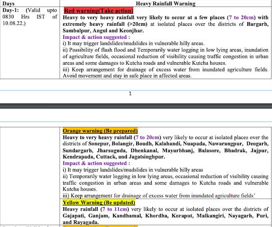
Bhubaneswar: With the low pressure over the Bay of Bengal intensifying into depression, the India Meteorological Department (IMD) on Tuesday issued a red warning for extremely heavy rainfall in some districts of Odisha in the next two days.
Heavy to very heavy rainfall is very likely to occur at a few places (7 to 20cm) with extremely heavy rainfall (>20cm) at isolated places in Bargarh, Sambalpur, Angul and Keonjhar districts. Heavy to very heavy rainfall (7 to 20cm) is also likely at isolated places in Sonepur, Balangir, Boudh, Kalahandi, Nuapada, Nabarangpur, Deogarh, Sundargarh, Jharsuguda, Dhenkanal, Mayurbhanj, Balasore, Bhadrak, Jajpur, Kendrapada, Cuttack
, and Jagatsinghpur during this period. Isolated places in Gajapati, Ganjam, Kandhamal, Khurda, Koraput, Malkangiri, Nayagarh, Puri, and Rayagada may experience heavy rainfall (7 to 11cm), the IMD said in its midday bulletin.
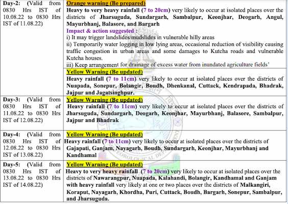
Check the forecast for the next 5 days


The IMD further said that the depression is likely to move west-northwestwards, maintain its intensity today and weaken gradually into a well-marked low-pressure area over Chhattisgarh and neighbourhood by Wednesday.
Fishermen have been advised against venturing into the sea with squally wind speed reaching 45-55 kmph gusting to 65 kmph is also likely over north-west adjoining west-central Bay of Bengal along and off Odisha till August 11, it added.