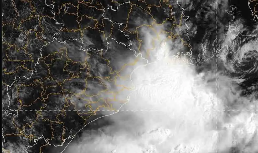
Bhubaneswar: Odisha has been placed under red alert for two days as a low-pressure area over the North Bay of Bengal is expected to intensify into a depression over the next 36 hours.
“The low pressure area over the North Bay of Bengal off West Bengal-Bangladesh coasts persisted over
the same region at 8.30 am on August 12. It is likely to become a well-marked Low Pressure are over the same region during the next 12 hours. Thereafter, it is likely to concentrate into depression and move Northwestwards across West Bengal and adjoining Bangladesh coasts during subsequent 24 hours,” the India Meteorological Department said in its midday bulletin on Wednesday.
The system is likely to trigger extremely heavy rainfall, gusty winds, and potential urban and localised flooding over the coming days.
Rainfall Warnings
The weather department has warned of light to moderate rain or thundershowers at most places across all districts of Odisha during the next 48 hours.
August 12
Red Warning: Extremely heavy rainfall is expected at isolated locations in Baleshwar and Bhadrak.
Orange Warning: Heavy to very heavy rainfall has also occur in Jajpur, Kendrapada, Jagatsinghpur, Kataka, Anugola, Kendujhar, Mayurbhanj, and Dhenkanal.
Yellow Warning Heavy rain is anticipated in Sundaragada, Sambalpur, Jharsuguda, Subarnapur, Boudh, Puri, Debagada, Khordha, and Nayagada.
Gusty surface winds reaching speeds of 30–40 kmph accompanied by thunderstorms and lightning may also occur across coastal and interior districts of Jajpur, Kataka, Baragada, Dhenkanal, Subarnapur, Boudh, Nuapada, Balangir, Kalahandi, Kandhamala, Nabarangpur, Rayagada, Koraput, Malkangiri, Gajapati, Ganjam, Puri, Khordha and Nayagada.
August 13
Red Warning: Extremely heavy rainfall shifts inland to isolated places over Kendujhar district.
Orange Warning: Heavy to very heavy rain may continue in Baleshwar, Jajpur, Kataka, Sundaragada, Sambalpur, Debagada, Anugola, Dhenkanal, and Mayurbhanj.
Thunderstorm accompanied by lightning and gusty surface wind (30-40 kmph) very likely to occur at one or
two places in the districts of Baleshwar, Bhadrak, Jajpur, Kendrapada, Jagatsingapur, Kataka, Sundaragada,
Jharsuguda, Baragada, Sambalpur, Debagada, Anugola, Dhenkanal, Kendujhar, Mayurbhanj, Subarnapur, Boudh, Nuapada,
Balangir, Kalahandi, Kandhamala, Nabarangpur, Rayagada, Koraput, Malkangiri, Gajapati, Ganjam, Puri, Khordha and Nayagada.
Rainfall intensity is expected to gradually decrease from August 14 onwards, though heavy rainfall warnings remain active for northwestern districts including Sundaragada, Jharsuguda, Sambalpur, and Kendujhar through August 17. Thunderstorm activity may also continue in Sundaragada, Jharsuguda, Sambalpur, Debagada, Anugola, Kendujhar, and Mayurbhanj during this period.
The weather office has urged authorities and residents to prepare for severe weather impacts, including localised and riverine flooding, urban traffic disruptions, landslides in vulnerable areas, and dangerously rough seas, while strictly advising fishermen off the Odisha coast to remain ashore from August 12 to 14.