Uttarkashi: Rescuers are using satellite images, provided by the Indian Space Research Organisation (ISRO), to try and rescue people affected by the deadly flash floods and mudslides in Uttarakhand’s Uttarkashi on Tuesday (August 5). Five deaths have been confirmed and at least 100 people are missing after houses and hotels at the Dharali village were swept away within minutes of the deluge.
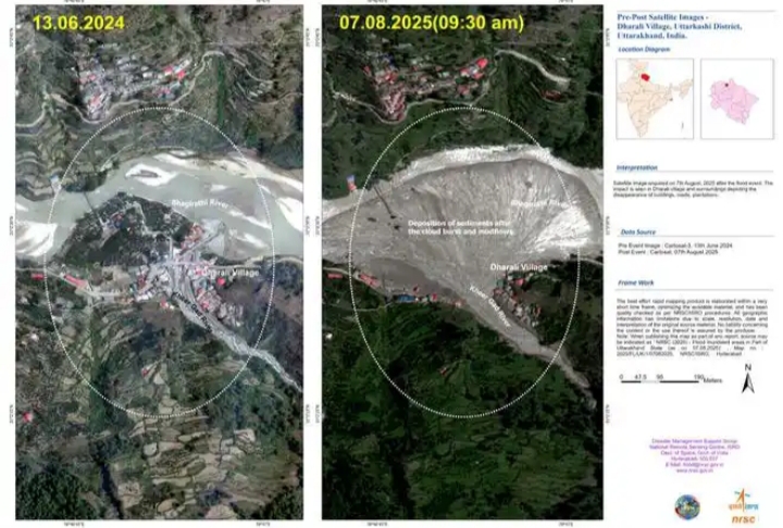
ISRO’s Cartosat-2S satellite captured high-resolution images of the affected zone two days after the disaster and the images reveal a large, fan-shaped deposit of mud and debris, covering nearly 20 hectares (approximately 750 metres by 450 metres), at Dharali village, where the Kheer Gad stream meets the Bhagirathi River.
According to ISRO, these maps are guiding search and rescue teams to priority locations, identifying submerged areas, and helping officials restore connectivity to cut-off villages. Among those missing are eight personnel of the Indian Army, which is playing a major role in rescue and relief operations.
After the floods, the National Remote Sensing Centre (NRSC) in Hyderabad conducted a rapid assessment, comparing the post-disaster images with cloud-free pre-event data from June 13, 2024. The analysis shows widened stream channels, altered river morphology, and severe destruction of infrastructure.
Several houses in the flood-affected zone have disappeared, likely swept away or submerged under mud and debris. Roads, bridges, plantations, and homes were either destroyed or heavily damaged.
The before-and-after images show the aftermath. Dharali and the Bhagirathi River appear intact in June 2024, with houses lining the riverbank. The August 2025 images show thick mud and sediment deposits across the floodplain, with many structures gone.
“A number of buildings appear to be submerged with mud-debris in Dharali village. The satellite images will assist ongoing search and rescue efforts to reach stranded individuals and restore connectivity to the isolated region,” ISRO has said in a statement.
The space agency also said the image showed the increasing vulnerability of Himalayan settlements to natural disasters.
The NRSC said the rapid mapping was conducted in a short timeframe and quality-checked under ISRO procedures. Geographic details are subject to limitations due to image resolution and interpretation.