Bhubaneswar: The well-marked low-pressure area over the north Bay of Bengal has concentrated into a Depression over Northwest Bay of Bengal and adjoining areas of coastal West Bengal and Bangladesh, the India Meteorological Department (IMD) informed on Friday.
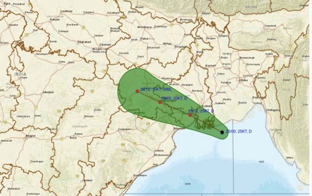
“The system moved slowly west-northwestwards and concentrated into a Depression over Northwest Bay of Bengal and adjoining areas of coastal West Bengal and Bangladesh, about 130 km south of Mongla (Bangladesh), about 150 km east-southeast of Sagar Island (West Bengal), about 170 km southeast of Kolkata (West Bengal).”
“It is likely to move west–northwestwards and cross West Bengal and adjoining Bangladesh coasts during forenoon. Thereafter, it may continue to move west-northwestwards across Gangetic West Bengal and adjoining North Odisha and Jharkhand during the subsequent 24 hours,” it added.
Under its influence, Odisha is likely to experience heavy to very heavy rainfall till July 28. Squally weather with wind speed reaching 35-45 kmph gusting to 55 kmph may prevail along & off Odisha coasts, West Bengal & Bangladesh coasts during this period.
TODAY’S FORECAST
The IMD has issued a red warning of extremely heavy rain accompanied by thunderstorm/lightning and gusty surface wind speed reaching 30-40 kmph at one or two places in Mayurbhanj and Keonjhar on July 25.
Heavy to very heavy rain along with thunderstorm/ lightning and gusty surface wind speed reaching 30-40 kmph may also occur at one or two places in Bargarh, Jharsuguda, Sambalpur, Deogarh, Angul, Dhenkanal, Sundargarh, Balasore, Bhadrak, and Jajpur. There is also a warning for heavy rain and thunderstorms with lightning and gusty surface wind speed reaching 30- 40 kmph for one or two places in Nuapada, Balangir, Sonepur, Boudh, Kalahandi and Nabarangpur.
Thunderstorm/lightning and gusty surface wind speed reaching 30-40 kmph may also occur at one or two places in Kendrapada, Cuttack, Jagatsinghpur, Puri, Khurda, Nayagarh, Ganjam, Gajapati, Kandhamal, Rayagada, Koraput and Malkangiri.