
Bhubaneswar: With a cold wave sweeping Odisha, Jharsuguda and Angul at 9.2°C and 9.6°C respectively, saw a sharp drop of 5.1°C in the minimum temperature from normal, on Friday morning, according to the India Meteorological Department (IMD).
G Udaygiri, a hill station in Kandhamal district, was the coldest at 5.4°C, followed by Semiliguda in Koraput at 8.1°C and Phulbani and Daringbadi, also in Kandhamal, at 8.5°C each. Bhawanipatna at 9.8°C was only other place in the state where the mercury levels dropped below 10°C.
The twin cities of Bhubaneswar and Cuttack also recorded below normal temperatures of 14.3°C and 13.6°C respectively.
The other places where mercury dropped below 15°C include Koraput (10°C), Rourkela (10.1), Chipilima in Bargarh (10.4°C), Ki
rei in Sundargarh (10.6°C), Balangir and Sundargarh at 11.2°C each, Keonjhar (11.8°C), Dhenkanal (12°C), Sonepur (12.4°C), Sambalpur (12.8°C), Nabarangpur and Titlagarh in Balangir at 13.2°C each, Hirakud (14°C), Ranital in Bhadrak (14.1°C), Nayagarh (14.2°C), Baripada (14.5°C) and Boudh (14.8°C).
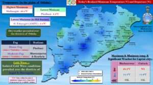

The IMD has warned of dense fog at one or two places in the districts of Sundargarh, Kandhamal, Koraput and Kalahandi till Sunday morning. It has also forecast a gradual rise in the night temperature by 2-4°C during the next 4 days with no large change thereafter.
Meanwhile, there is no indication of any likely impact of cyclonic storm Ditwah over coastal Sri Lanka and adjoining southwest Bay of Bengal, on Odisha. The system is expected to move northnorthwestwards across Sri Lanka coast and adjoining southwest Bay of Bengal and reach over southwest Bay of Bengal near North Tamil Nadu, Puducherry and adjoining south Andhra Pradesh coasts by early morning of November 30.