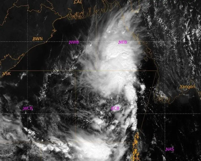
Bhubaneswar: The India Meteorological Department (IMD) has issued a Special Bulletin, putting Andhra Pradesh and adjoining South Odisha coasts under a yellow warning (Pre-Cyclone Watch) as the well-marked low pressure area over the eastcentral and adjoining southeast Bay of Bengal is set to intensify into a cyclonic storm by the morning of October 26.
Storm Trajectory and Intensification Timeline
The system is expected to intensify into a depression on Saturday before intensifying further into a deep depression on October 25. By the morning of October 26, it will evolve into a cyclonic storm, to be named Arnab, over the westcentral Bay of Bengal.
As the storm moves closer to the Andhra Pradesh and southern Odisha coasts, wind speeds over the central Bay of Bengal are expected to reach gale force (70–80 kmph, gusting to 90 kmph) by October 26, with further intensification expected as the system nears the coastline around October 28.
Red Alert for Southern Districts
The IMD has issued a Red Warning for southern districts of Odisha including Rayagada, Koraput, Malkangiri, Gajapati, and Ganjam on October 28. These regions may experience scattered heavy to very heavy rainfall, with isolated extremely heavy rainfall (>20 cm). The downpour will be accompanied by severe thunderstorms, lightning, and gusty surface winds reaching 60–70 kmph with gusts up to 80 kmph.
Also Read: Zero-Casualty Mission: Odisha Shuts Schools, Orders Removal Of Festival Arches Amid Cyclone Threat
Orange and Yellow Warnings Across Odisha
The rainfall may expand across the state leading up to and following the storm’s peak:
October 27: An Orange Warning has been issued for coastal and southern districts of Jagatsinghpur, Puri, Rayagada, Koraput, Malkangiri, Gajapati, and Ganjam for heavy to very heavy rainfall, alongside wind speeds of 40–50 kmph. A Yellow Warning covers central and northern districts of Baleshwar, Bhadrak, Jajpur, Kendrapada, Kataka, Kendujhar, Mayurbhanj, Kandhamala, Kalahandi, Nawarangpur, Khordha and Nayagada. Thunderstorm accompanied by lightning and gusty surface wind (30-40 kmph gusting to 50 Kmph) maya also occur at one or two places in the districts of Baleshwar, Bhadrak, Jajpur, Kendrapada, Jagatsinghpur, Kataka, Kendujhar, Mayurbhanj, Kandhamala, Kalahandi, Nawarangpur, Khordha and Nayagada.
October 28: An Orange Warning covers 18 districts of Baleshwar, Bhadrak, Jajpur, Kendrapada, Jagatsinghpur, Kataka, Mayurbhanj, Sonpur, Boudh, Nuapada, Balangir, Kalahandi, Kandhamala, Nawarangpur, Baragada, Puri, Khordha, and Nayagada, which may experience heavy to very heavy rain and wind gusts up to 60 kmph.
A yellow warning for heavy rainfall has also been issued for the districts of Sundaragada, Jharsuguda, Sambalpur, Debagada, Anugola, Dhenkanal and Kendujhar. Thunderstorm accompanied by lightning and gusty surface wind (30-40 kmph gusting to 50 Kmph) may occur at one or two places in the districts of Baleshwar, Bhadrak, Jajpur, Kendrapada, Jagatsinghpur, Kataka, Sundaragada, Jharsuguda, Baragada, Sambalpur, Debagada, Anugola, Dhenkanal, Kendujhar, and Mayurbhanj.
October 29: As the system shifts, northern districts of Baleshwar, Sundaragada, Jharsuguda, Sambalpur,
Kendujhar, Mayurbhanj remain under an Orange Warning for heavy to very heavy downpours, along with thunderstorm accompanied by lightning and gusty surface wind (40-50 kmph gusting to 60 Kmph).
Heavy rain, along with thunderstorm, lighting and wind gusts up to 50 Kmph, may also continue to lash Bhadrak, Jajpur, Kendrapada, Jagatsinghapur, Baragada, Debagada, Anugola, Dhenkanal, Sonpur, Nuapada and Balangir.
Fishermen Warnings Issued
Sea conditions are expected to deteriorate dramatically: Rough to Very Rough conditions will prevail off the Andhra Pradesh–Odisha coasts starting October 27. High to Very High seas are expected over the westcentral and northwest Bay of Bengal between October 26 and October 28.
Fishermen are strictly advised not to venture into the deep sea or along the Andhra Pradesh and Odisha coasts from October 26 through October 28. Those currently at sea have been urged to return to shore immediately.
Severe Potential Impacts
The state disaster authorities and IMD have outlined several key operational and infrastructure risks:
Strong winds are expected to cause damage to kutcha structures, break tree branches, and disrupt power/communication lines. Waterlogging and urban inundation could lead to major traffic disruptions and road closures. Standing crops, banana, and papaya plantations are also at high risk of damage due to high wind speeds and field inundation. Hilly regions in southern Odisha face threats of localized landslides and mudslides, while prolonged rainfall may trigger riverine flooding in vulnerable catchments.
Marine transportation, small boats, trawlers, and offshore operations will be impacted. Helicopter services and recreational tourism activities along coastal areas are to be strictly regulated.
Residents in vulnerable regions are urged to monitor official advisories, avoid unnecessary travel, unplug electronic equipment during thunderstorms, and remain prepared to relocate to cyclone shelters if instructed by local authorities.