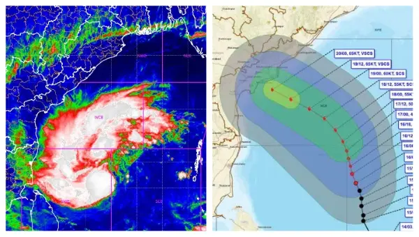
Bhubaneswar: A deep depression over the southeast and adjoining southwest Bay of Bengal is expected to intensify into a cyclonic storm by Monday evening.
Once it reaches cyclonic storm strength, the system will be named Akvan meaning ‘an evil mind’, a name contributed by Iran. This would mark the third cyclone to form over the Bay of Bengal in three weeks, following Arnab and Murasu.
According to the latest bulletin from the India Meteorological Department, the system moved north-northwestwards at about 8 kmph over the past six hours and was centred at 5:30 am on Monday, about 630 km east-northeast of Trincomalee in Sri Lanka, 680 km west of Sri Vijaya Puram in the Andaman and Nicobar Islands, 720 km east-southeast of Chennai, 820 km south-southeast of Visakhapatnam, and 940 km south of Gopalpur in Odisha.
IMD forecasts indicate the deep depression is very likely to continue on a north-northwestward track and strengthen into a cyclonic storm over the central parts of the south and adjoining west-central Bay of Bengal by November 16 evening. It is then expected to intensify further into a severe cyclonic storm over the west-central Bay of Bengal by the evening of November 17. Thereafter, the system is likely to gain additional strength and move northwestwards, reaching the west-central Bay of Bengal near the Andhra Pradesh coast around the night of November 19 as a very severe cyclonic storm.
The Joint Typhoon Warning Centre has noted that atmospheric conditions remain moderately favourable for development, aided by strong westward upper-level outflow and warm sea surface temperatures of 29–30°C. Global models show some differences in the pace of intensification, with some suggesting a broader circulation while others indicate a tighter system consolidating more quickly, but they broadly agree on a slow northward track in the near term followed by a northwestward turn.
IMPACT ON ODISHA
The developing system is expected to bring significant rainfall and strong winds to several coastal states. Odisha is on high alert, with light to moderate rain likely at many places on November 18 and heavy rainfall at isolated locations. From November 19 to 21, light to moderate rain is forecast at most places across the state, with heavy to very heavy falls at isolated spots, particularly in southern and coastal districts such as Gajapati, Ganjam, Puri, Rayagada, Koraput and Malkangiri. Squally winds of 40–50 kmph gusting to 60 kmph are likely along and off the Odisha coast on November 18, increasing to 50–60 kmph gusting to 70 kmph from November 19 until the morning of November 20.
Authorities have cautioned about the risk of landslides, mudslides, waterlogging in low-lying areas and damage to vulnerable structures.
In anticipation of the heavy rain, the Ganjam district administration in Odisha has begun releasing water from two major reservoirs as a precautionary measure. One gate each of the Ghodahada and Baghalati reservoirs was opened late on Sunday night, with releases of approximately 34.77 cubic metres per second from Ghodahada and 30.72 cubic metres per second from Baghalati.
Officials aim to reduce water storage levels from around 75 per cent to 60 per cent and are closely monitoring inflow, outflow and downstream conditions to prevent flooding.
Rain is also expected in parts of Tamil Nadu, Puducherry, Andhra Pradesh and West Bengal under the system’s influence, with fishermen advised to avoid venturing into affected sea areas in the Bay of Bengal and Andaman Sea in the coming days. Coastal administrations in the region remain on alert as the system continues to organise and track toward the Andhra Pradesh coast.