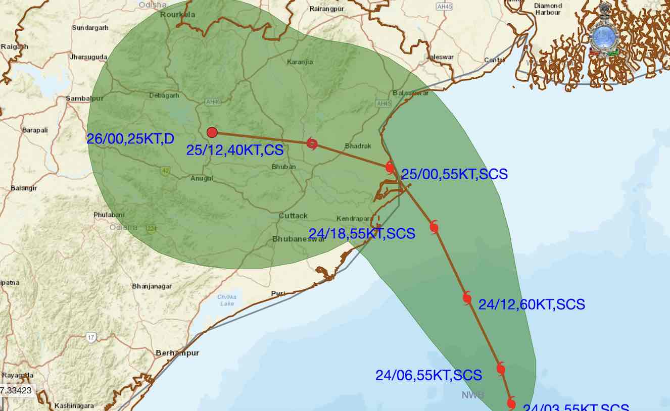
Bhubaneswar: Cyclone ‘Dana’ has intensified into a severe cyclonic storm over Northwest & adjoining Central Bay of Bengal and make landfall along Odisha coast between Bhitarkanika National Park and Dhamra port in Odisha, a stretch of about 70 km, with a maximum sustained wind speed of 100-110 kmph gusting 120 kmph, from midnight till early Friday morning.
The storm was about about about 260 km southeast of Paradip (Odisha), 290 km south-southeast of Dhamara (Odisha) and 350 km south of Sagar Island (West Bengal). at 5.30 am, according to the India Meteorological Centre (IMD).
According to the latest forecast track of Cyclone Dana issued by the IMD, the system is likely to make landfall in Dhamra area of Bhadrak district in Odisha.

Here are 10 must know about Cyclone ‘Dana’
1. Eleven districts – Balasore, Bhadrak, Kendrapada, Jagatsinghpur, Puri, Khurda, Mayurbhanj, Keonjhar, Jajpur, Cuttack and Dhenkanal – may face the maximum impact of the system and have been put on high alert.
2. Storm surge is likely to be 1.0 to 2.0 m height above astronomical tide and inundate low-lying areas of Kendrapada, Bhadrak and Balasore districts at the time of landfall, which will take around four to five hours. Storm surge of 0.5 to 1.0 m is also likely in Jagatsinghpur district of Odisha during the time of landfall.
3. IMD has warned of uprooting of trees, breaking of tree branches, damage to kutcha houses, electric poles and other infrastructure as heavy rainfall, wind and storm surge will peak on October 24 (midnight) and continue till October 25 forenoon. Roads in some areas of Balasore, Bhadrak, Bhitarkania and Puri were blocked, after trees were uprooted due to strong winds this morning.
4. It also cautioned that low-lying areas in these districts could face flooding during the cyclone’s landfall. Low to moderate flash flood risk is likely in Balasore, Bhadrak, Gajapati, Ganjam, Jagatsinghpur, Kendrapada, Keonjhar, Jajpur, Khurda, Mayurbhanj, Nayagarh and Puri districts.
5. Red warning of extremely heavy rainfall has been issued for Jagatsinghpur, Kendrapada, Cuttack, Bhadrak, Jajpur, Balasore, and Mayurbhanj districts on October 24 and Mayurbhanj, Keonjhar, Balasore, Bhadrak on October 25.
6. Gale with wind speed reaching 60-70 kmph gusting to 80 kmph is currently prevailing along and off Odisha coast. It would gradually increase becoming 100-110 kmph gusting to 120 kmph along & off north Odisha and east Medinipur district of West Bengal from October 24 afternoon till October 25 morning and decrease gradually thereafter. Gale wind speed reaching 60-80 kmph gusting to 90 kmph is likely along & off south Odisha and remaining districts of coastal West Bengal from October 24 evening till October 25 morning and decrease gradually thereafter.
7. While Kendrapara, Bhadrak and Balasore are in high-risk zones as wind velocity could touch 100-110 kmph, gusting to 120 kmph, Mayurbhanj wmay experience wind speed of 80-90 kmph, gusting to 100 kmph. Similarly, the districts of Jagatsinghpur, Cuttack and Jajpur are likely to witnessed wind speed of 60-80 kmph, gusting to 90 kmph and the wind speed will be 60-70 kmph, gusting to 80 kmph in Puri, Khurda, Dhenkanal and Keonjhar. In Bhubaneswar, heavy rainfall is expected, wind speed will slowly increase, and the highest wind speed is likely to occur tonight.
8. The IMD has issued a “great danger signal No-10” for Puri, Dhamra, and Paradip ports, while Gopalpur port is under signal-8 warning. All fishing activities have been suspended.
9. The severe cyclonic storm is likely to re-curve slightly towards west and west-southwards after landfall, triggering rain in southern Odisha around October 26
10. Dana is a name suggested by Qatar according to the tropical cyclone naming system formulated by the WMO and in Arabic it means “the most perfectly sized, valuable and beautiful pearl”.
According to the IMD, the cyclonic storm is weaker than Cyclone Amphan of 2020, which struck Sundarbans in South 24 Parganas district of West Bengal on May 20, causing large-scale damage in the coastal and northern districts of Odisha, including Kendrapada, Jagatsinghpur, Bhadrak, Balasore and parts of Mayurbhanj.
Also Read: Odisha Receives Heavy Rain As Cyclone ‘Dana’ Barrels Towards Coast; IMD Issues Red Message
Cyclone Yaas was the last to hit Odisha. The ‘Very Severe Cyclonic Storm’ battered the northern coastline of Odisha with powerful winds and rains as it made landfall at Bahanaga block in Balasore with a sustained wind speed of 130 to 140 kmph gusting up to 155 kmph on May 26, 2021, leaving behind a trail of devastation, flattening kuchha houses, uprooting trees and electric poles, and causing rivers to swell.


