Bhubaneswar: Odisha is likely to experience heatwave conditions due to the possible cyclonic storm, which is expected to form over Bay of Bengal around May 9.
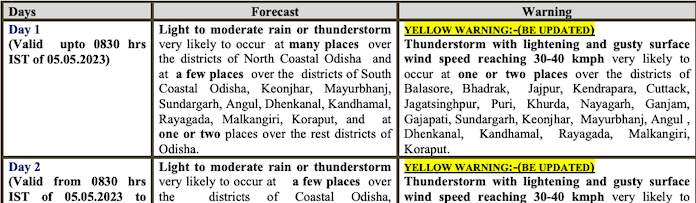
While the India Meteorological Department (IMD) has issued yellow warning for thunderstorm with lightning and gusty surface wind speed reaching 30-40 kmph for two days, the day temperature in the state may touch 40 degree Celsius by May 7.
According to Director of the Centre for Environment and Climate (CEC) Sarat Chandra Sahu, the state is likely to experience extreme heat if the cyclone heads towards Bangladesh-Myanmar as it would cut off the wind blowing from the sea. Instead heatwave spell will return with hot, dry winds blowing from the northwest.
“The temperature will fall from May 12 if the cyclone makes the landfall near Odisha coast. If it changes it direction then sky will remain clear and the temperature may cross 42 degree Celsius at many places due to onslaught of hot and dry westerly winds from May 7,” he said.
With the northwesterly winds blowing towards the Bay of Bengal, where the system is strong, and the temperature may shoot up to 44-45 degree Celsius by May 12 and May 13, he added.
On the path and intensity of the possible cyclone, Sahu said things will become clearer once the system intensifies into a depression.
In its midday bulletin, the IMD said that Odisha is likely to experience a gradual rise in the day temperature after two days. By March 7, the mercury may soar past 40 degree Celsius in several western Odisha districts.
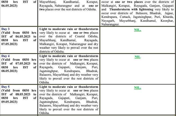
CHECK FORECAST FOR NEXT 5 DAYS
The IMD further informed that a cyclonic circulation is likely to develop over Southeast Bay of Bengal around May 6. Under its influence a low pressure area is likely to form over the same region around May 7. It is likely to concentrate into a depression over Southeast Bay of Bengal on May 9. Thereafter, it is likely to intensify into a cyclonic storm while moving nearly northwards towards central Bay of Bengal. The details of its path and intensification will be provided after the formation of low pressure area, it added.
Also Read: Where Is Possible Cyclone Mocha Heading? Check IMD GF & Other Forecast Models
The IMD GF model indicated that the system may intensify up to very severe category storm and move towards Bangladesh-Myanmar coast.
The MeT office has also issued an advisory for fishermen, warning them against venturing into the sea from May 7.
Also Read: Cyclone Mocha: Check Expected Weather & Advisory By IMD


