Bhubaneswar: Cyclone Mocha has heralded the return of peak summer heat over Odisha with the India Meteorological Department (IMD) predicting a further rise in the day temperature across the state after May 13.
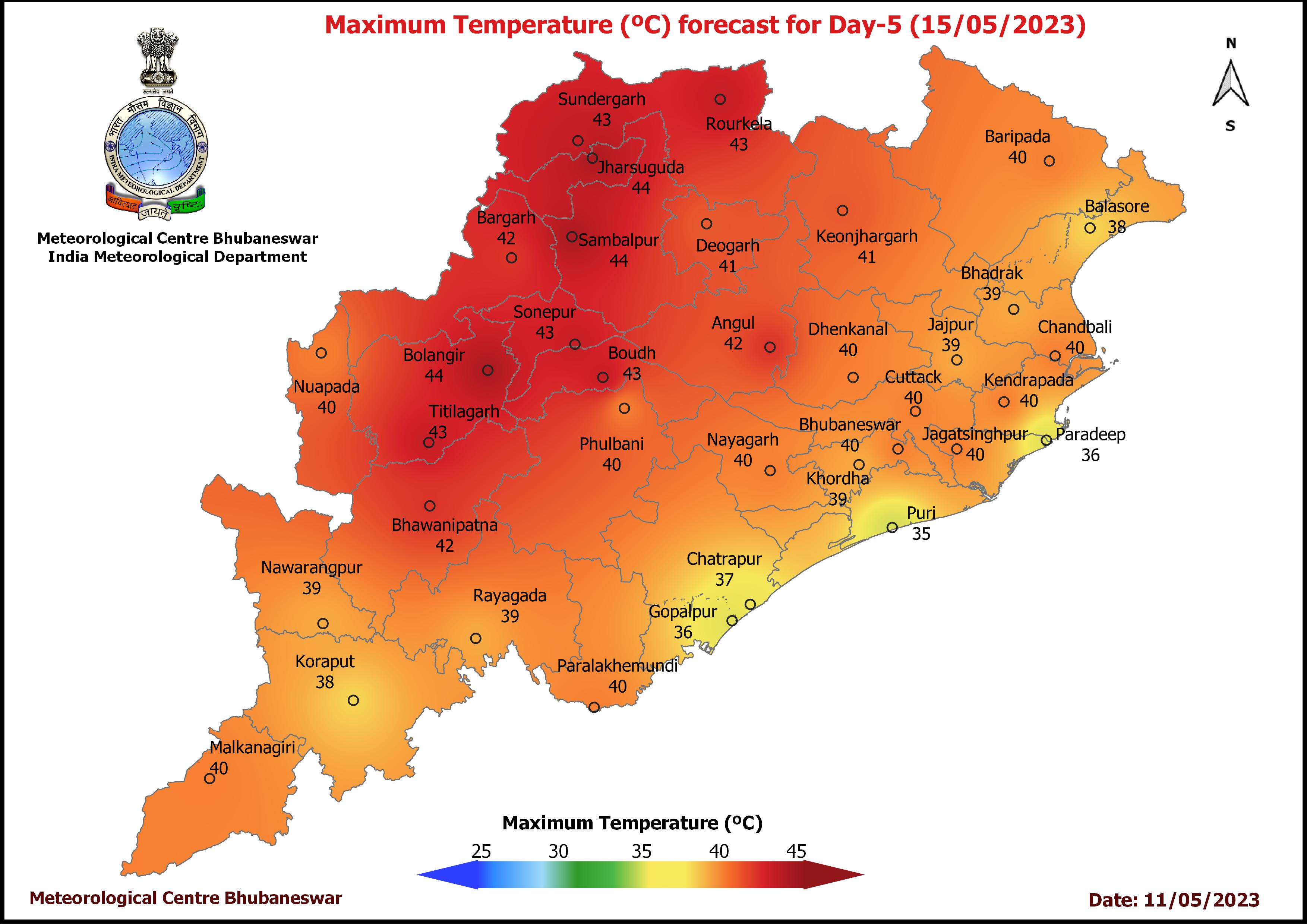
“There will be no large change in the maximum temperature during the next 4 days and the mercury level will rise thereafter over the districts of Odisha. The day temperature is likely to be 40oC and above at a few places in Interior Odisha during the next 5 days and people may experience hot and discomfort weather during this period,” according to the midday bulletin.
Notably, Sambalpur was the hottest place at 43.2oC by 2.30 pm followed by Jharsuguda (42.4), Hirakud (41.6), Keonjhar (37.8) and Bhubaneswar (37). The mercury is likely to soar to 40oC and above at most places in Odisha by May 15.
According to weather experts, the system moving in anti-clockwise motion will drag all moisture from the surrounding region, including the land. This will result in a steady flow of dry land breeze over the state, leading to a rise in temperature.
Yellow warning for thunderstorm with lightning has been issued for one or two places in Keonjhar, Mayurbhanj, Balasore, Bhadrak, Jajpur, Dhenkanal, Gajapati and Ganjam till Friday morning. Light to moderate rain is also likely at one or two places in coastal Odisha Keonjhar, Mayurbhanj, Dhenkanal, Kandhamal, Koraput, Rayagada and Malkangiri during this period.
Yellow warning continues for the subsequent 24 hours with thunderstorm with lightning forecast for one or two places in Mayurbhanj, Balasore, Bhadrak, Kendrapara, Jagatsinghpur, Puri and Ganjam. Light to moderate rain is also at one or two places in coastal Odisha Keonjhar and Mayurbhanj.
While there is no further warning, the some parts of coastal and southern districts of the state may experience till May 16 morning.
Meanwhile, cyclonic storm “Mocha” over southeast Bay of Bengal has moved north-northwestwards with a speed of 8 kmph during past 6 hours, and lay centered about 510 km west of Port Blair, 1,160 km south-southwest of Coxs Bazar (Bangladesh) at 11.30 am over the same region.
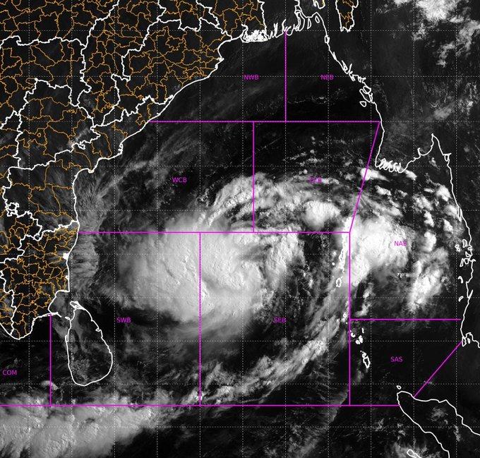
It is very likely to move north-northwestwards and gradually intensify into a severe cyclonic storm around midnight. Thereafter, it is likely to recurve gradually, move north-northeastwards from May 12 morning and intensify further into a very severe cyclonic storm by evening over central Bay of Bengal. It would reach its peak intensity around May 13 evening. It is likely to cross southeast Bangladesh and north Myanmar coasts between Cox’s Bazar (Bangladesh) and Kyaukpyu (Myanmar), close to Sittwe (Myanmar) around noon of May 14 with maximum sustained wind speed of 140-150 kmph gusting to 165 kmph, the IMD said.
However, no warning has been issued for Odisha regarding wind speed or rainfall. “The cyclone will move towards Bangladesh-Myanmar coasts, so there will be no impact on Odisha. However, the conditions will be very rough in the deep sea,” said IMD Director General Mrutyunjay Mohapatra.
Fishermen, ships, boats and trawlers have been advised not to venture into southeast Bay of Bengal and adjoining Andaman Sea till May 13, central Bay of Bengal and north Andaman Sea till May 14, and into northeast and adjoining northwest Bay of Bengal from May 12-14. Distant warning signal no-2 (DW-2) has been hoisted at all ports of Odisha.


