Bhubaneswar: Cyclonic storm ‘Remal’, which is expected to form over Eastcentral Bay of Bengal by May 25 morning, may trigger heavy to very heavy rain in four districts of Odisha amid the continuing thunderstorm activity, the India Meteorological Department informed on Friday.
It is likely to cross Bangladesh and adjoining West Bengal coasts between Sagar Island and Khepupara as a Severe Cyclonic Storm.
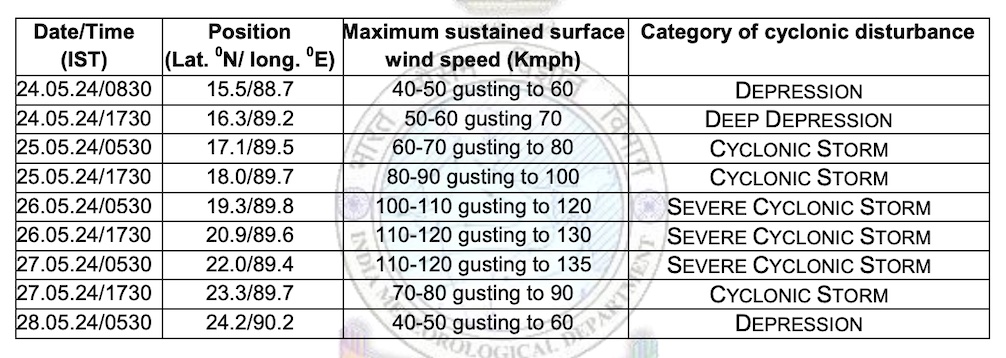
“The Depression over Central Bay of Bengal has moved northeastwards with a speed of 20 kmph during past 3 hours, and lay centered over the same region about 730 km south-southwest of Khepupara (Bangladesh) and 750 km south of Canning (West Bengal). It is very likely to continue to move northeastwards and intensify further into a cyclonic storm over Eastcentral Bay of Bengal by May 25 morning. Subsequently, it would move nearly northwards, intensify into a severe cyclonic storm by May 25 night. Continuing to move nearly northwards, it is very likely to cross Bangladesh and adjoining West Bengal coasts between Sagar Island and Khepupara around May 26 midnight as a severe cyclonic storm.”
FORECAST TRACK & INTENSITY
If the system develops into a cyclone, it will the first during this pre- monsoon season, and be named Remal, meaning ‘sand’ in Arabic, as suggested by Oman.
The weather agency has issued yellow warning of heavy rain rainfall for isolated places in Balasore, Bhadrak, and Kendrapada on May 25. Light to moderate rain/thundershower may also occur at many places in north coastal Odisha, and at a few places in south coastal Odisha and at one or two places in remaining districts of the state.
Thunderstorm with lightning accompanied by gusty surface wind speed reaching 40-50 kmph is also likely at one or two places in Bhadrak, Balasore, Kendrapada, Mayurbhanj, Keonjhar, Dhenkanal, Jajpur, Cuttack, Jagatsinghpur, Khurda and Puri.
On May 26, heavy to very heavy rainfall may lash isolated places in Balasore and Bhadrak. Heavy rainfall is also likely at isolated places in Kendrapada and Mayurbhanj districts. Light to moderate rain/thundershower may occur at most places in north coastal Odisha, and at a few places in south coastal Odisha, north interior Odisha and one or two places in remaining districts of the state.
Thunderstorm with lightning accompanied by gusty surface wind speed reaching 40-50 kmph may also occur at one or two places in Balasore, Bhadrak, Mayurbhanj, Keonjhar, Dhenkanal, Angul, Jagatsinghpur, Jajpur, and Kendrapada.
Squally wind speed reaching 40-50 kmph gusting to 60 kmph is likely along and off North Odisha coasts from May 25 evening. It is likely to increase becoming gale wind speed reaching 60-70 kmph gusting to 80 kmph from morning of May 26 and continue for the subsequent 24 hours.
Rough to very rough sea condition is likely along and off North Odisha coasts from May 25 evening till May 27 morning. All ports in Odisha have been advised to hoist Distant Cautionary Signal No-I (DC-I).
Light to moderate rain/thundershower will continue in North, South and Coastal Odisha from May 27- 30. The day temperature is also expected to gradually rise by 2-3 degree Celsius at many places in the state after 3-4 days, the MeT office added.
