Bhubaneswar: Cyclonic storm ‘Remal’, which is likely to form over Bay of Bengal by Saturday evening, may trigger heavy rain in four districts of Odisha amid the continuing thunderstorm activity, the India Meteorological Department (IMD) said.
It is likely to cross Bangladesh and adjoining West Bengal coasts between Sagar Island and Khepupara as a Severe Cyclonic Storm by the midnight of Sunday.
Several parts of Odisha are likely to get isolated heavy to very heavy rain (115.5-204.4 mm) on Sunday under the influence of the cyclonic storm.
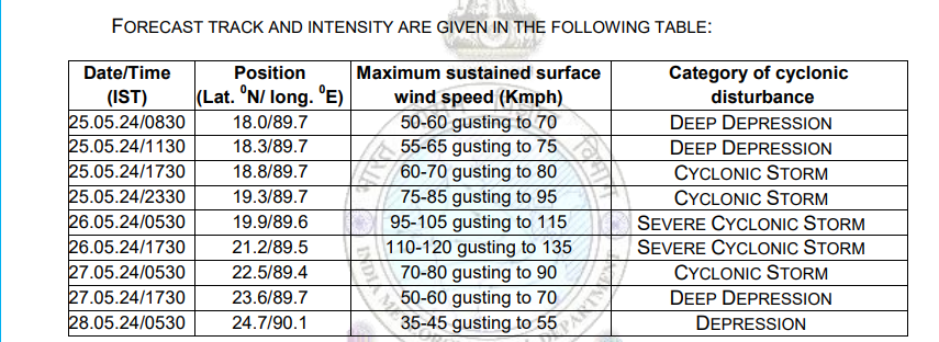
“The Depression over Eastcentral Bay of Bengal moved north-northeastwards with a speed of 15kmph intensified into a Deep Depression at 530 hour of today, 25th May 2024 and moved further nearly northwards with a speed of 17 kmph during past 06 hours and lay centered at 0830 hrs IST of 25th May, 2024 over the same region near latitude 18.0°N and longitude 89.7°E, about 440 km south-southwest of Khepupara (Bangladesh), 440 km south-southeast of Sagar Islands (West Bengal) and 480 km south-southeast of Canning (West Bengal),” the weather agency said.
It is likely to continue to move nearly northwards and intensify into a cyclonic storm over eastcentral & adjoining north Bay of Bengal around Saturday evening.
Continuing to move further northwards, it would intensify into a severe cyclonic storm by May 26 morning and cross Bangladesh & adjoining West Bengal coasts between Sagar Island and Khepupara by May 26 midnight as a severe cyclonic storm with wind speed of 110-120 gusting to 135 kmph.
Under its impact, heavy rain (7 to 20cm) is likely to occur at isolated places over Balasore, Bhadrak, Jagatsinghpur & Kendrapada districts by Sunday morning. The weather agency issued yellow warning for rain.
Similarly, heavy to very heavy rain (7 to 12cm) is likely to occur at some places over Balasore and Bhadrak districts and heavy rainfall (7 to 11cm) at isolated places over Mayurbhanj between Sunday morning and Monday morning.

Squally wind speed reaching 50-60 kmph gusting to 70 kmph is prevailing over central Bay of Bengal. It is likely to become gale wind speed reaching 60-70 kmph gusting to 80 kmph soon. It would increase further and extend to adjoining areas of north Bay of Bengal becoming gale wind speed reaching 70-80 kmph gusting to 90 kmph from evening of Saturday and 100-110 kmph gusting to 120 kmph over north Bay of Bengal from morning and 110-120 kmph gusting to 135 kmph from evening of Sunday.
Rough to very rough sea condition is prevailing over central Bay of Bengal. It would become high over central Bay of Bengal. It will be high to very high over north Bay of Bengal from till May 27 morning.
The sea condition is also likely to be rough to very rough in central and adjoining south Bay of Bengal during the period.
The IMD has advised the fishermen not to venture into south Bay of Bengal and those in deep sea return to the coast. It has also advised to hoist distant cautionary signal at all ports of Odisha.
In view of the impending cyclonic storm, the Special Relief Commissioner (SRC) has issued advisory to the districts to remain alert and vigilant. The Collectors of Balasore, Bhadrak, Kendrapada and Jagatsinghpur have been asked to keep a close watch and monitor the situation.


