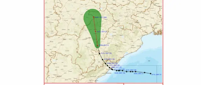
Bhubaneswar: The deep depression over south Odisha has weakened into a depression on Friday, even as heavy rain continued to batter south and western regions, the India Meteorological Department (IMD) said.
The system moved north-north-westwards with a speed of 15 kmph and lay centred at 5.30 am over south interior Odisha and adjoining Chhattisgarh, close to Nuapada.
Its centre is about 90 km west-northwest of Titlagarh, 100 km northwest of Bhawanipatna, 110 km east-northeast of Kanker (Chhattisgarh) and 120 km southeast of Raipur (Chhattisgarh).
The system is likely to continue to move north-north-westwards and maintain its intensity of depression during the next 12 hours and weaken into a well-marked low pressure area during the subsequent 12 hours.
The system is under continuous surveillance by the Doppler Weather Radars at Sambalpur and Raipur.
With heavy rain in different parts of Odisha persisted under its influence, districts such as Koraput, Kalahandi and Nabarangpur have been placed under a red warning for the day. Rainfall intensity may remain high in many parts of Odisha.
The depression is expected to move towards Chhattisgarh later in the day. This may lead to heavy rainfall in southern and western Odisha. The impact is likely to be more pronounced in areas adjoining Chhattisgarh.
Nuapada district has been placed under an orange alert, with heavy to very heavy rainfall likely at one or two places. People have been advised to remain alert as the weather system continues to influence the region.
A yellow alert has also been issued for Sundaragada, Baragada, Kendujhar, Mayurbhanj, Balangir, Kalahandi, Nabarangpur, Koraput and Malkangiri districts, where heavy rain is expected during the day.