Bhubaneswar: Heavy rain together with thunderstorm activity is likely to continue for at least five more days in many parts of Odisha, even as the depression over Jharkhand weakened into a well-marked low pressure.
The depression over Jharkhand and neighbourhood moved west-north-westwards, weakened into a well-marked low pressure area and lay over north Jharkhand and adjoining south Bihar, the India Meteorological Department (IMD) said on Tuesday.
It is likely to move further west-north-westwards across Jharkhand and south Bihar towards east Uttar Pradesh during next 24 hours.
Though Odisha is not directly under the system’s core, its outer bands and associated monsoon activity are already impacting northern and coastal parts of the state.
Squally wind speed reaching 30-40 kmph gusting to 50 kmph is likely to be experienced over north Odisha during next 24 hours
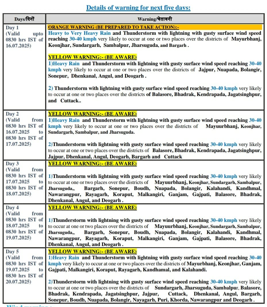
The IMD has issued an orange warning of heavy to very heavy rain and thunderstorm with lightning with gusty surface wind speed reaching 30-40 kmph at some places of Mayurbhanj, Keonjhar, Sundargarh, Sambalpur, Jharsuguda, and Bargarh districts by Wednesday morning.
Similarly, heavy rain and thunderstorm with lightning with gusty surface wind speed reaching 30-40 kmph may occur at one or two places over the districts of Jajpur, Nuapada, Balangir, Sonepur, Dhenkanal, Angul, and Deogarh during the period.
Thunderstorm with lightning with gusty surface wind speed reaching 30-40 kmph may occur at one or two places of Balasore, Bhadrak, Kendrapada, Jagatsinghpur, and Cuttack districts.
On July 16-17, heavy rain and thunderstorm with lightning with gusty surface wind speed reaching 30-40 kmph may occur at one or two places over the districts of Mayuurbhanj, Keonjhar, Sundargarh, Sambalpur, and Jharsuguda.
Thunderstorm with lightning with gusty surface wind speed reaching 30-40 kmph may occur at one or two places over the districts of Balasore, Bhadrak, Kendrapada, Jagatsinghpur, Jajpur, Dhenkanal, Angul, Deogarh, Bargarh and Cuttack.


