Bhubaneswar: People of Odisha can expect respite from the sweltering heat from Wednesday with the India Meteorological Department predicting a gradual fall in day temperature by 3 to 5 degree Celsius during the next 3 days.
“Maximum temperature (day temperature) is very likely to fall gradually by 3 to 5 degree Celsius during the next 3 days and no large change thereafter at many places over the districts of Odisha. Consequently, heatwave conditions are likely to abate from districts of Odisha from tomorrow onwards,” it said.
Till 2.30 pm, three places in the state recorded 40°C and above with Jharsuguda being the hottest at 40.8°C followed by Sambalpur (40.4°C), Hirakud (40°C), Chandbali 38.2°C and Bhubaneswar (37.6°C) amid heatwave warning for a few places in Sundargarh, Jharsuguda, Bargarh and Balangir. The IMD has issued no further warning.
The MeT office further said that thunderstorm with lightning and gusty surface windspeed reaching 40-50 kmph may occur at one or two places in Keonjhar, Mayurbhanj, Balasore, Jajpur, Bhadrak, Gajapati, Ganjam and Kandhamal till 8.30 am on Wednesday. Thunderstorm with lightning is also likely at one or two places in Kendrapada, Cuttack, Jagatsinghpur, Puri, Khurda, Nayagarh, Angul, Dhenkanal, Boudh, Kalahandi, Rayagada, Koraput, Malkangiri and Nabarangpur. There is also a forecast for light to moderate rain or thunderstorm at many places in Malkangiri, Koraput, Rayagada, Nabarangpur, Gajapati, Ganjam and Kandhamal and at a few places in remaining parts of the state.
Similar weather conditions will prevail the following day.
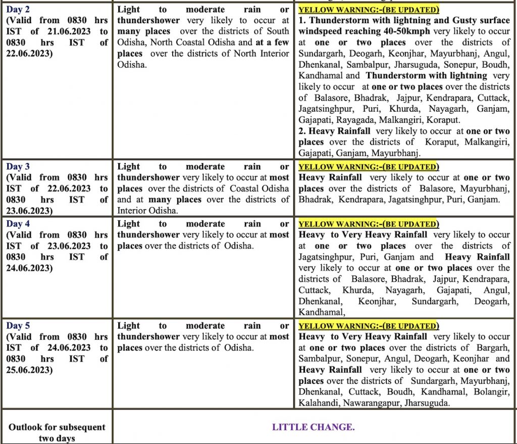
The IMD has forecast heavy rain from June 22 and the intensity of the spell is likely to increase in the next two days with no change thereafter.
June 22: Heavy Rainfall very likely to occur at one or two places in Balasore, Mayurbhanj, Bhadrak, Kendrapasa, Jagatsinghpur, Puri and Ganjam.
June 23: Heavy to very heavy rainfall very likely to occur at one in Jagatsinghpur, Puri and Ganjam. Heavy rainfall also likely at one or two places in Balasore, Bhadrak, Jajpur, Kendrapada, Cuttack, Khurda, Nayagarh, Gajapati, Angul, Dhenkanal, Keonjhar, Sundargarh, Deogarh and Kandhamal.
June 24: Heavy to very heavy rainfall very likely to occur at one in Bargarh, Sambalpur, Sonepur, Angul, Deogarh, Keonjhar and Heavy rainfall also likely at one or two places in Sundargarh, Mayurbhanj, Dhenkanal, Cuttack, Boudh, Kandhamal, Balangir, Kalahandi, Nabarangapur, Jharsuguda.
Light to moderate rain or thundershower is likely at most places in Odisha during this period.
Notably, the MeT office had earlier predicted the onset of southwest monsoon over the state during the next 2-3 days. “Conditions are favourable for further advance of Southwest Monsoon over some more parts of south Peninsular India, some parts of Odisha, some more parts of Gangetic West Bengal, Jharkhand, Bihar and East Uttar Pradesh during next 2-3 days,” it said.
CHECK THE FORECAST HERE
