Bhubaneswar: The well-marked low pressure area over interior Odisha and strong monsoon current is likely to bring more rains to Odisha during the next 5 days, the India Meteorological Department (IMD) informed on Sunday.
While the system is likely to move northwestwards across Chhattisgarh and weaken gradually into a low-pressure area during next 12 hours, the Monsoon trough is passing through Jaisalmer, Kota, Guna, Mandla and centre of well-marked low pressure areas over interior Odisha and adjoining Chhattisgarh, Chandbali and hence east-southeastwards to eastcentral Bay of Bengal, it further stated.
The weather agency has issued yellow warning for heavy rainfall (7 to 11cm) at one or two places in Nuapada, Balangir, Sonepur, Boudh, Bargarh, Sambalpur, Deogarh, Jharsuguda, Sundargarh, Nabarangpur, Kalahandi, Koraput and Malkangiri on July 21.
Bhubaneswar may experience cloudy sky with possibility of moderate rain or thunderstorm.
Heavy rain may continue at one or two places in Kendrapada, Bhadrak, Balasore, Jajpur, Keonjhar, Mayurbhanj, Sundargarh, Jharsuguda, Bargarh and Sambalpur during the subsequent 24 hours.
On July 23, there is a forecast for heavy rainfall at one or two places in Mayurbhanj, Keonjhar, Sundargarh, Jharsuguda, Koraput, Rayagada, Kalahandi, Kandhamal and Nabarangpur districts.
The IMD said that squally weather with gusty surface wind speed reaching 40-50 kmph is very likely to prevail over northwest and adjoining westcentral Bay of Bengal and along and off Odisha coasts till July 23 due to strong monsoon current. Since sea condition is likely to be rough to very rough, fishermen have been advised not to venture into sea, along and off Odisha coasts, northwest and adjoining westcentral Bay of Bengal during this period.
While there is no warning for July 24, heavy rainfall may resume at one or two places in Balasore, Bhadrak, Jajpur, Kendrapada, Cuttack, Jagatsinghpur, Angul, Dhenkanal, Mayurbhanj, Keonjhar, Deogarh, Sundargarh and Sambalpur on July 25.
Light to moderate rain/thundershower may continue at many places across the state during the subsequent 2 days.
Meanwhile the prolonged spell has brought down the rainfall deficit to 17% in Odisha. The state has recoded cumulative rainfall of 359.5mm against its normal value of 434.1mm between June 1 and July 20.
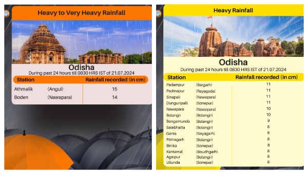
During the last 24 hours, Nuapada received an average rainfall of 96.1mm, followed by Sonepur (73.6mm) and Boudh (66.5mm). The highest rainfall of 154.4mm was recorded in Athamallik block of Angul district. Five blocks (Athamallik of Angul district, Padmapur of Bargarh district, Boden, Sinapali of Nuapada districts, Dunguripali of Subarnapur district) received more than 100mm rainfall. The average rainfall of the state was 26.2mm.
RAINFALL IN LAST 24 HOURS
