Bhubaneswar: A low-pressure area is likely to form over northwest Bay of Bengal and adjoining coastal areas of West Bengal and Odisha during the next 24 hours, the India Meteorological Department (IMD) informed on Sunday.
“An upper air cyclonic circulation over northwest Bay of Bengal adjoining West Bengal and north Odisha coasts has moved over north Bay of Bengal. Under its influence, a low-pressure area is likely to form over northwest Bay of Bengal and adjoining coastal areas of West Bengal and Odisha during next 24 hours.”
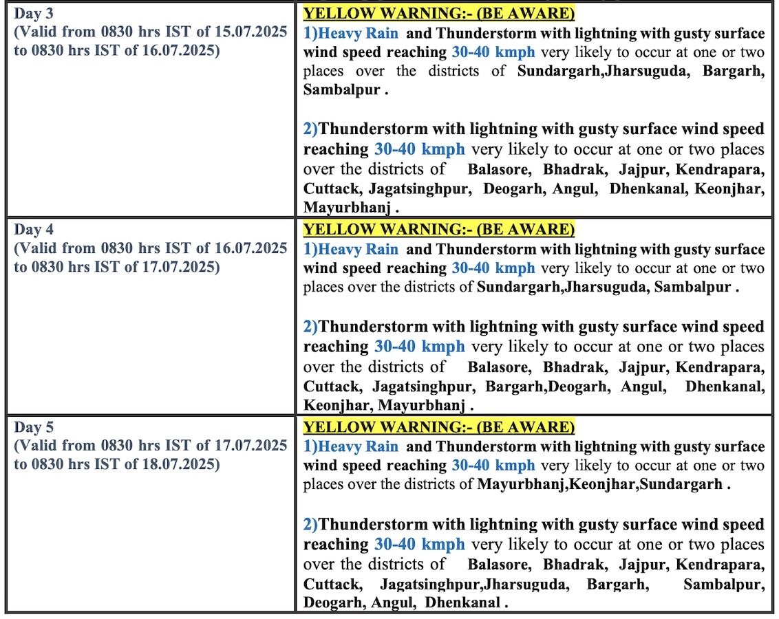
The system, along with monsoon trough passing from Bikaner to northeast Bay of Bengal, is likely to trigger heavy to very heavy rainfall accompanied by thunderstorm activity and lightning in Odisha till July 17.
The weather agency has issued an orange warning for two days. Heavy to very heavy rain along with thunderstorm/lightning and gusty surface wind speed reaching 30-40 kmph may occur at one or two places in Mayurbhanj, Keonjhar and Sundargarh districts on July 12; and Mayurbhanj, Keonjhar, Sundargarh, Sambalpur, Jharsuguda and Bargarh on July 13.
It has warned of damage to standing crops, banana and papaya trees, vulnerable structures, power and communication lines along with flooding of roads and water logging in low-lying areas, closure of underpasses and poor visibility in urban areas of Mayurbhanj, Keonjhar, Sundargarh, Sambalpur, Jharsuguda and Bargarh districts. Landslides may also occur in hilly terrain due to heavy rainfall.
Heavy rain accompanied by thunderstorm/lightning and gusty surface wind speed reaching 30-40 kmph is also likely at one or two places in Balasore, Bhadrak, Jajpur, Kendrapara, Angul, Dhenkanal, Deogarh, Cuttack, Nayagarh, Kalahandi, Koraput, Rayagada and Sambalpur during the next 12 hours. There is also a warning for thunderstorm/lightning with gusty surface wind speed reaching 30-40 kmph for one or two places in Jagatsinghpur, Jharsuguda, Bargarh,Puri, Khurda, Ganjam and Gajapati during this period.
On July 13, the IMD has also issued yellow warning of heavy rain accompanied by thunderstorm/lightning and gusty surface wind speed reaching 30-40 kmph at one or two places in Angul, Dhenkanal, Cuttack, Nayagarh, Boudh, Sonepur, Deogarh, Bolangir, Kandhamal and Kalahandi. Thunderstorm/lightning with gusty surface wind speed reaching 30-40 kmph may also occur at one or two places over the districts of Balasore, Bhadrak, Jajpur, Kendrapada, Jagatsinghpur, Puri, Khurda, Ganjam, Gajapati.
Check forecast for next three days