Bhubaneswar: With monsoon becoming active again and formation of a low pressure over North Odisha and adjoining Gangetic West Bengal & Jharkhand, the state has been experiencing heavy rain for past 24 hours and orange alert has been issued for eight districts till 8.30 am on Monday.
“Under the influence of cyclonic circulation over Northwest Bay of Bengal and adjoining north Odisha, Gangetic West Bengal coasts, a low pressure area has formed over North Odisha and adjoining Gangetic West Bengal & Jharkhand. It is likely to moves west-northwestwards across Jharkhand during next 2 days,” the India Meteorological Department (IMD) informed.
The monsoon trough is now passing through Ganganagar, Narnaul, Aligarh, Varanasi, Daltonganj, centre of low pressure area over North Odisha and adjoining Gangetic West Bengal & Jharkhand and thence, southeastwards to eastcentral Bay of Bengal.
It further informed that a cyclonic circulation is likely to form over Northwest Bay of Bengal around July 18, which is likely to increase the intensity of rain in the state. “In view of the above meteorological features, wet spells of monsoon rainfall activity likely to continue over Odisha with isolated heavy to very heavy rainfall,” the weather agency said.
According to the midday bulletin, heavy to very heavy rainfall is likely at one or two places in Jharsuguda, Sambalpur, Sundargarh, Bargarh, Nuapada, Sonepur, Balangir and Deogarh on July 16. Heavy Rainfall may occur at one or two places in Kalahandi, Kandhamal, Boudh, Angul, Keonjhar, Mayurbhanj, Dhenkanal, Jajpur, Nabarangpur, Koraput and Malkangiri districts with light to moderate rain at most places in the state during this period.
The weather agency has warned of temporary waterlogging in low-lying areas, poor visibility during intense spell of rain and traffic congestion in urban areas and possibility of wall collapse in vulnerable kutchha houses.
Yellow warning for heavy rainfall continues for some parts of coastal and southern districts of Odisha till July 19. Heavy to very heavy rain may occur again at one or two places in Gajapati, Ganjam, Kandhamal, Kalahandi, Rayagada, Koraput, Nabarangpur with heavy rain one or two places in Bhadrak, Kendrapara, Jagatsinghpur, Cuttack, Khurda, Puri, Nayagarh, Balangir, Nuapada on July 20.
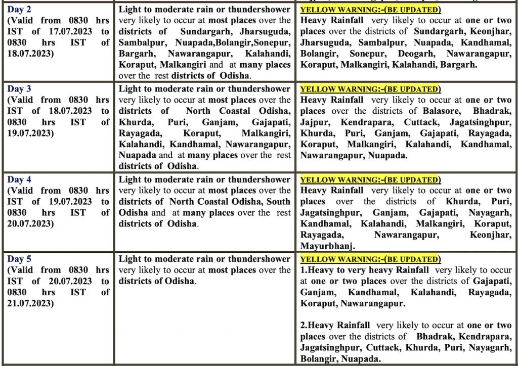
The IMD has forecast an increase in the intensity of rain in the subsequent two days.
In the last 24 hours, the state received 27.3 mm rainfall, which is 103% more than the normal of 23.5mm. The highest of 215 mm rainfall was recorded at Kirmira block in Jharsuguda district. The waterlogging in Bhubaneswar, following heavy rain on Saturday, led to traffic jams and caused difficulty for people to drive vehicles in knee-deep water at many places while many slums and low-laying areas were submerged under water.
The state’s special relief commissioner has asked all district collectors to be prepared to evacuate people from low-lying areas and face any exigency. Field-level functionaries were asked not to leave the headquarters.
Notably, the SOA University’s Centre for Environment and Climate (CEC) had earlier corroborated the prediction about formation of a cyclonic circulation, which will increase precipitation in the state from July 18, and lead to the formation of a low-pressure area the same day. “The system may gradually intensify into a deep depression by July 20. Under its influence, heavy to very heavy rainfall could occur at most places between July 21 and 23 across north and western Odisha,” said CEC director Sarat Chandra Sahu.
