Rare Twin Storms In Indian Seas After 5 Yrs; Check Latest Update On Cyclones Tej & Hamoon
Bhubaneswar: The formation of twin cyclones in the Arabian Sea and the Bay of Bengal, in a rare phenomenon and was last seen five years ago, in 2018, when cyclones– Luban and Titli– occurred at the same time.
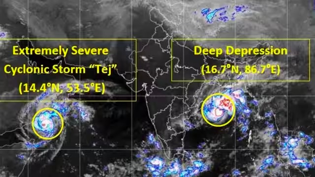
According to India Meteorological Department, Extremely Severe Cyclonic Storm ‘Tej’ over Westcentral Arabian Sea continued to move northwestwards with a speed of 13 kmph during past 6 hours and lay centered at 5.30 am over the same region on Monday, about 200 km north-northwest of Socotra (Yemen), 300 km south of Salalah (Oman) and 240 km southeast of Al Ghaidah (Yemen). “It is very likely to continue to move northwestwards and weaken into a Very Severe Cyclonic Storm during next 6 hours. It is likely to cross Yemen coast close to AlGhaidah around early hours of October 24 as a Very Severe Cyclonic Storm with wind speed of 125-135 kmph gusting to 150 kmph,” it added.
Meanwhile, another cyclone is likely forming on the other coast, in the Bay of Bengal, which has been given the monicker Hamoon. The Deep Depression is currently located in westcentral Bay of Bengal after moving northeastwards on Sunday night. It lies centred around 400 km from Odisha’s Paradip and 550 km south-southwest of Digha in West Bengal. “It is likely to intensify into a cyclonic storm during next 12 hours,” the weather agency said in its morning bulletin.
As per the IMD’s latest projected cyclone track, Hamoon would weaken as it nears the Bangladesh coast. “It is very likely to move nearly north-northeastwards and cross Bangladesh coast between Khepupara and Chittagong around October 25 evening as a Deep Depression.”
Also Read: Cyclone Hamoon To Form In Bay Of Bengal Today; Rain, Squall@70 Kmph Along Odisha Coast
According to private forecaster Skymet , both cyclones when formed, will be separated by a large distance of over 2500 km and traverse their track independently. The cyclones would have no significant impact on the weather with a slight weather change expected in Chennai and the coastal regions of Tamil Nadu, as they move away.
Skymet also noted that the early development of storms in the Indian Seas this season leaves a slim chance for a similar occurrence before the end of this year.
Notably, the North Indian Ocean — comprising the Bay of Bengal and the Arabian Sea — have remained highly active. The post-monsoon months between October and December are prone to cyclonic storms, with November being the most favourable for the development of storms.
Comments are closed.