Bhubaneswar: The Indian Meteorological Department (IMD) on Wednesday said that Cyclone Mocha forming over the Bay of Bengal is likely to intensify into a very severe storm by May 12 and the wind speed can reach 130 kmph during landfall over Southeast Bangladesh and North Myanmar coasts between Cox’s Bazar (Bangladesh) and Kyaukpyu (Myanmar) around forenoon of May 14.
“The depression over southeast Bay of Bengal moved west-northwestwards with a speed of 5 kmph during past 6 hours, intensified into a Deep Depression and lay centered at 5.30 am today (May 10) over the same region, about 540 km west-southwest of Port Blair, 1460 km south-southwest of Cox’s Bazar (Bangladesh) and 1350 km south-southwest of Sittwe (Myanmar). It is very likely to move northwestwards for some time and then north-northwestwards and intensify gradually into a cyclonic storm over the same region around today evening. Then continuing to move north-northwestwards, it will gradually intensify further into a severe cyclonic storm by May 11 morning and very severe cyclonic storm by May 12 morning over southeast and adjoining central Bay of Bengal,” the Met office said.
Thereafter, it is likely to recurve gradually, move north-northeastwards and weaken slightly from May 13 and cross southeast Bangladesh and north Myanmar coasts between Cox’s Bazar (Bangladesh) and Kyaukpyu (Myanmar) around forenoon of May 14.
According to senior meteorologist Jason Nicholls, Depression over Bay of Bengal will become cyclonic storm on Wednesday. “A north-northwest track through Thursday, then turn north-east. Mocha will impact Bangladesh & Myanmar as a severe cyclonic storm or very severe cyclonic storm this weekend,” he tweeted.
During the course of recurvature, coastline of North Odisha and West Bengal will fall within strike range, albeit mild, to witness cloudy sky, possibly strong winds and may be rains as well. Sea condition will be terribly rough for boats, trawlers and fishing vessels, a report published in Skymetweather said.
The centre of the storm should pass, keeping safe distance from Odisha and West Bengal coast. Broad area of coast between Cox’s Bazar (Bangladesh) and Kyaukpya (Myanmar) looks more probable for landfall. It is bit early to predict the exact location for crossing of storm and more clarity will come only after commencement of recurvature,” it added.
WARNINGS
(i) Rainfall
Andaman & Nicobar Islands: Rainfall at most places with heavy to very heavy rainfall at isolated/some places is likely to continue till May 11. Heavy rainfall at isolated places over Andaman Islands is likely on May 12.
(ii) Fishermen Warning
Fishermen, small ships, boats and trawlers are advised not to venture into Southeast and Central Bay of Bengal and south Andaman Sea. Those over central Bay of Bengal and north Andaman Sea are advised to return by May 10.
(iii) Advisory
Regulation of tourism and offshore activities and shipping near Andaman and Nicobar Islands till May 12.
Regulation of shipping activity over the sea areas of southeast & central Bay of Bengal and Andaman Sea till May 13.
Regulation of shipping activity over the sea areas of northeast Bay of Bengal during May 12-14.
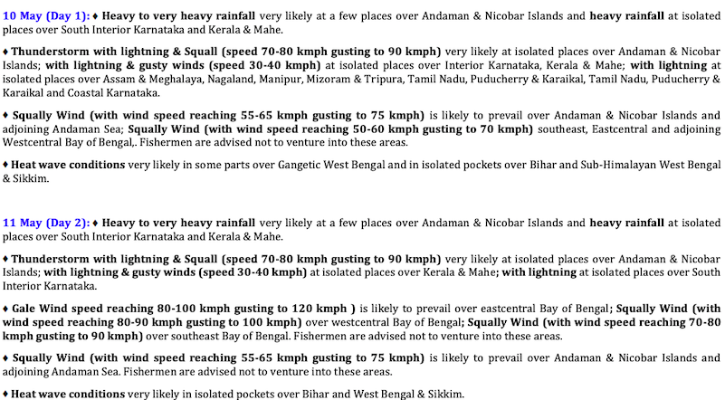
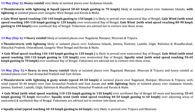
The IMD has also forecast thunderstorm/lightning/gusty winds with light/moderate scattered to fairly widespread rainfall over Kerala & Mahe during the next 5 days and Karnataka during next 3 days with light isolated to scattered rainfall over rest parts of the region during next 2 days. Heavy rainfall is likely at isolated places over Kerala & Mahe and South Interior Karnataka during May 10-11.
Scattered to fairly widespread rainfall is also likely over Arunachal Pradesh and isolated rainfall over Assam and Meghalaya during next 5 days. Heavy rainfall may occur at isolated places over Nagaland, Manipur, Mizoram and Tripura on May 13 and very heavy rainfall at isolated places over the region May 14.Heavy rainfall is likely at isolated places over east Assam and east Arunachal Pradesh on May 14.
NEXT 5 DAYS


