Bhubaneswar: Odisha is likely to witness an increase in thunderstorm activity accompanied by gusty surface wind speed reaching 40-50 kmph till March 19, the India Meteorological Department (IMD) informed on Thursday.
The MeT office has attributed it to moisture incursion from the Bay of Bengal and development of a favourable wind pattern. Light to moderate rain is also likely across the state for the next five days. One or two places in Keonjhar, Jajpur, Dhenkanal, Cuttack, Koraput and Malkangiri are also likely to experience hailstorm on March 18.
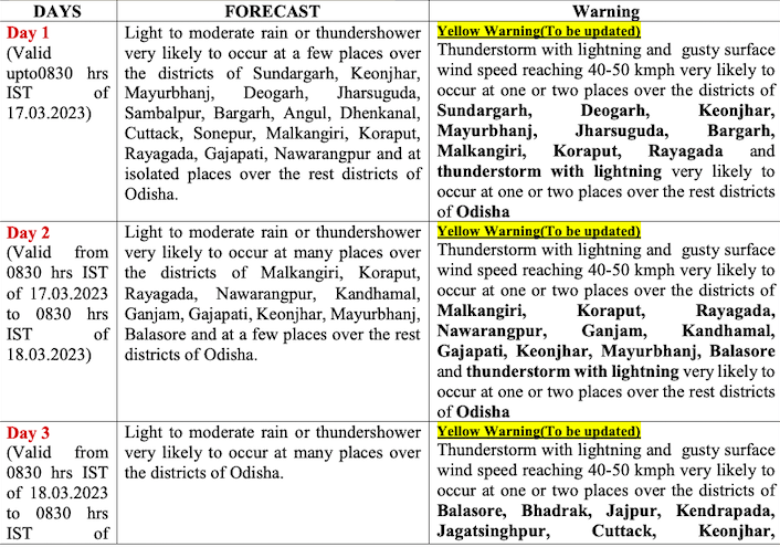
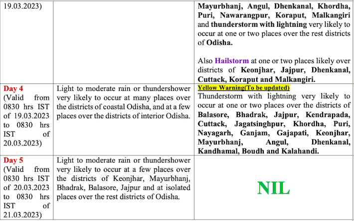
Former director of the regional IMD centre Sarat Chandra Sahu said thunderstorm is likely to continue till March 21, leading to a drop in day temperature. Both coastal and north Odisha pockets would witness thundersquall along with hailstorm for three days from March 16, he added.
The maximum temperature dropped below 38 degree Celsius on Wednesday as Jharsuguda recorded 37.8 degree Celsius followed by Sambalpur (37.6) and Malkangiri (37.4). Bhubaneswar and Cuttack saw a sharp fall in temperature and recorded 28 degree Celsius (-7.8) and 28.4 degree Celsius (-7) respectively. The mercury is likely to hover around 29-32 degree Celsius in the twin cities during the next five days, the IMD added.


