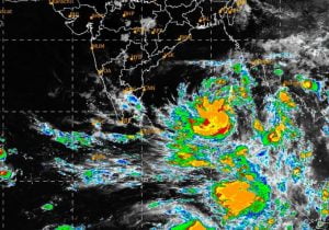
Bhubaneswar: The low pressure area became more marked and now lies as a well-marked low pressure area over southeast Bay of Bengal and adjoining south Andaman Sea. It is very likely to move north-westwards and intensify into a depression over south-east Bay of Bengal during the next 12 hours, the Meteorological Centre in Bhubaneswar said on Saturday morning.
It will further intensify into a cyclonic storm over east-central Bay of Bengal by May 8 evening. It is very likely to continue to move north-westwards and reach west-central and adjoining north-west Bay of Bengal off north Andhra Pradesh-Odisha coasts by May 10, it said. The place and time of landfall is not clear yet.
Special Relief Commissioner P K Jena on Friday evening said that the state government was fully prepared for relief and rescue operations if the cyclone heads towards Odisha.
Collectors of 18 districts have been asked to undertake all measures and stay prepared. As many as 17 NDRF, 20 ODRAF and 175 fire services teams are on high alert.
Appealing to people not to panic, Jena advised fishermen not to venture into the sea after May 8 and asked those in deep seas to return to the coast. Indian Navy and Coast Guard are maintaining vigil on movement of fishermen.


