Cyclone ‘Dana’: Extremely Heavy Rain & Strong Wind To Batter Odisha, Red Alert For 8 Dists

Bhubaneswar: Heavy rain may commence in coastal Odisha on October 23 with the formation of the possible Cyclone Dana over Eastcentral Bay of Bengal, the India Meteorological Department (IMD) informed on Monday.
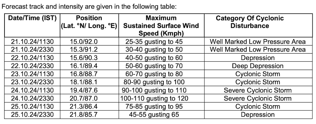
“The well-marked low-pressure area over Eastcentral Bay of Bengal is expected to move west-northwestwards and intensify into a depression by October 22 morning and into a cyclonic storm by October 23 over the same region.”
The intensity of rain is likely to increase as the system is expected to move northwestwards and reach northwest Bay of Bengal off Odisha-West Bengal coasts by October 24 morning. “Continuing to move northwestwards, it is very likely to cross north Odisha and West Bengal coasts between Puri and Sagar Island during night of October 24 and early morning October 25 as a severe Cyclonic Storm with a wind speed of 100-110 kmph gusting 120 kmph,” it added.
Also Read: Cyclone ‘Dana’ To Cross Coasts Between Puri & Sagar Island By October 24-25
According to the weather agency, light to moderate rainfall may occur at most places in Odisha with heavy rainfall (07-11 cm) at isolated places in Balasore, Bhadrak, Kendrapada, Jagatsingpur, Puri, Khurda, Ganjam and Gajapati on October 23.
Yellow warning of heavy rainfall (7 to 11cm) accompanied by thunderstorm and lightning has been sounded for isolated places in Balasore, Bhadrak, Jajpur, Kendrapdra, Jagatsinghpur and Puri districts.
On October 24-25, heavy to very heavy rainfall is likely at a few places and extremely heavy rainfall (≥ 21 cm) at isolated places in Balasore, Mayurbhanj, Bhadrak, Kendrapada, Jagatsingpur Keonjhar, Jajpur, Cuttack and Dhenkanal and Puri districts.
Also Read: Cyclone ‘Dana’ To Reach Odisha Coast By October 24; Know Who Named It & The Meaning
Red warning has been issued for Balasore, Mayurbhanj, Bhadrak, Kendrapada, Jagatsingpur, Jajpur and Cuttack on October 24 and Balasore, Mayurbhanj, Bhadrak, Keonjhar on October 25.
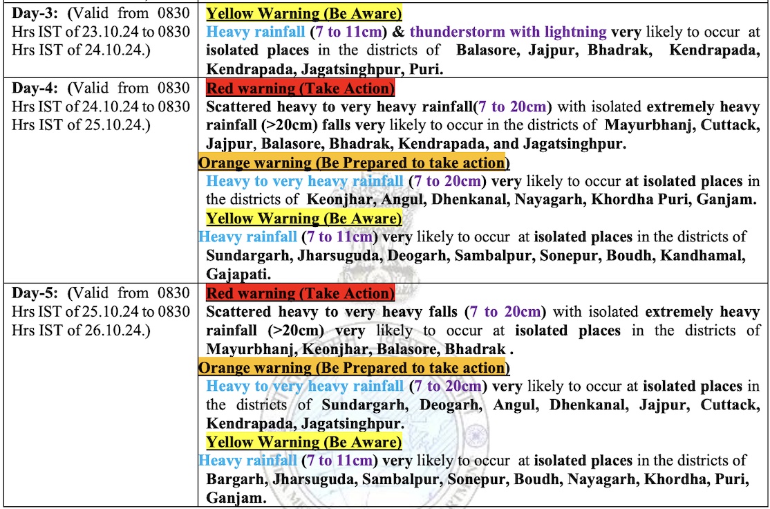
The IMD has also issued orange warning of heavy to very heavy rainfall (7 to 20cm) for isolated places in Puri, Ganjam, Khurda, Nayagarh, Keonjhar, Angul, Dhenkanal districts on October 24. Heavy rain may also occur at isolated places in Gajapati, Kandhamal, Boudh, Sonepur, Sambalpur, Deogarh, Jharsuguda and Sundargarh.
On October 25, orange warning of heavy to very heavy rainfall (7 to 20cm) has been sounded for isolated places in Jagatsinghpur, Kendrapada, Cuttack, Jajpur, Dhenkanal, Angul, Deogarh and Sundargarh districts. Heavy rainfall (7 to 11cm) is also likely at isolated places in Ganjam, Puri, Khurda, Nayagarh, Boudh, Sonepur, Sambalpur, Bargarh and Jharsuguda.
Squally wind speed reaching 40-50 gusting to 60 kmph may commence along and off Odisha-West Bengal coasts from October 23 evening. It would gradually increase becoming gale wind speed reaching 100-110 kmph gusting to 120 kmph from October 24 night till October 25 morning. “Sea condition is likely to be rough to very rough from October 23 evening and would become high from October 24 evening to October 25 forenoon,” the MeT office said.
Fishermen have advised not to venture into North Bay of Bengal and along & off Odisha, West Bengal and Bangladesh coasts from October 23-25.
Also Read: Odisha’s Trysts With Tropical Storms Since 1999 Super Cyclone; The Hits & Misses
The weather agency has also warned of flash flood/waterlogging in low-lying areas, inundation of agriculture field and mudslides/landslides in vulnerable hilly areas. The heavy downpour may lead to significant rise in water level of rivers. There is also a possibility of damage to vulnerable structure, unmetalled roads and thatched houses/huts. The gale can lead to breaking of tree branches and uprooting of trees and cause moderate damage to banana and papaya trees and minor damage to power and communication lines.
Waterlogging is also likely in underpass road and there can be occasional reduction in visibility during heavy rainfall, causing traffic congestion in urban areas.