Bhubaneswar: While the Deep Depression over westcentral Bay of Bengal is expected to intensify into a cyclonic storm during next 6 hours, the India Meteorological Department (IMD) on Monday issued yellow warning of heavy rain for three districts of Odisha.
According to the special bulletin, heavy rainfall (7 to 11 cm) may occur at one or two places in Bhadrak, Kendrapada and Jagatsinghpur till 8.30 am on Tuesday.
Light to moderate rain/thundershower is also likely in some parts of Bhadrak, Puri, Jajpur, Kendrapada, Jagatsinghpur, Khurda, Cuttack, Balasore, Mayurbhanj, Dhenkanal, Ganjam, Gajapati and Keonjhar, including twin cities of Bhubaneswar and Cuttack, till 5.30 pm. People have been advised to keep a watch on the weather and accordingly move to safer places to protect themselves from lightning strikes.
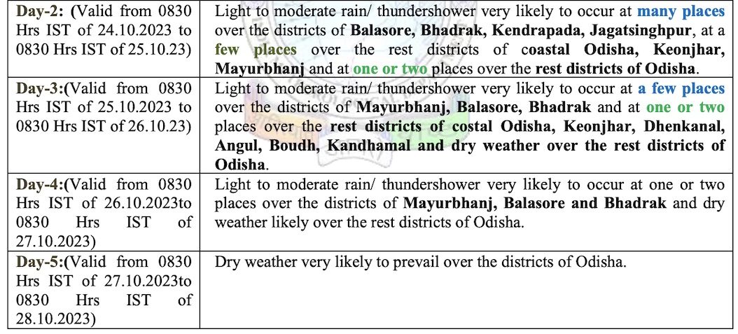
There is also a forecast for light to moderate rain/thundershower at many places in Balasore, Bhadrak, Jajpur, Kendrapada, Cuttack, Jagatsinghpur, Puri, at a few places in remaining coastal Odisha, at one or two places in Sundargarh, Deogarh, Keonjhar, Mayurbhanj, Angul, Dhenkanal, Boudh, Kandhamal, Rayagada, Koraput and Malkangiri, during the day.
While light to moderate rain is likely to continue in some districts of the state during the next 3 days, the intensity of downpour may gradually decrease.
The cyclonic storm, after its formation, will be called ‘Hamoon’, a name given by Iran based on the formula followed for naming cyclones in the Indian Ocean Region. It may then move nearly north-northeastwards and cross Bangladesh coast between Khepupara and Chittagong around evening of October 25 as a Deep Depression, the IMD informed.
Under its influence, squally wind speed reaching 40-50 kmph gusting to 60 kmph is likely from October 23 evening to 24 along and off Odisha coast and it is likely to increase gradually becoming gale with wind speed of 50-60 kmph gusting to 70 kmph from October 24-26.
Also Read: Cyclone Hamoon To Take Shape In Bay Of Bengal In 6 Hours; Odisha Govt Issues Advisory
Sea condition will be rough on October 23, becoming very rough to high from October 24-26 over North Bay of Bengal, along and off Odisha coast. Fishermen have been advised not to venture into westcentral Bay of Bengal till October 25 and along and off Odisha coast and north Bay of Bengal during October 23-25. Those in deep sea have been advised to return to the coast.
Ports in Odisha have been asked to hoist Local Cautionary Signal No-3 (LC-3).
Also Read: Rare Twin Storms In Indian Seas After 5 Yrs; Check Latest Update On Cyclones Tej & Hamoon


