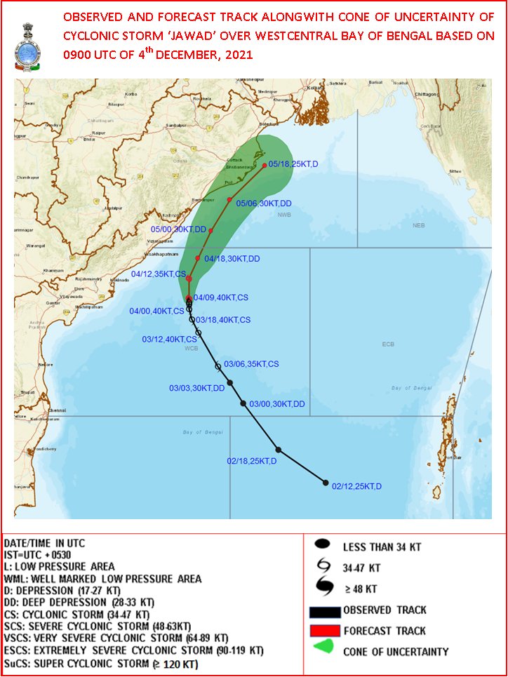
Bhubaneswar: Cyclone Jawad moved slightly northwestwards with a speed of 3 kmph during the past 6 hours and is about 310 km south-southwest of Gopalpur, 380 km south-southwest of Puri and 470 km south-southwest of Paradip in Odisha.
According to the India Meteorological Department (IMD), it is likely to move nearly northwards and weaken into a Deep Depression during the next 6 hours and then move north-northeastwards along Odisha coast and reach near Puri around Sunday noon.
The system is expected to weaken further and continue to move north-northeastwards along Odisha coast towards West Bengal.
RAIN FORECAST
Till 8.30 am on Sunday
Red Warning: Heavy to very heavy rainfall is very likely to occur at isolated places in Puri, and Jagatsinghpur.
Orange Warning: Heavy to very heavy rainfall is very likely to at one or two places in Balasore, Bhadrak Kendrapada, Jajpur, Cuttack, Khordha, Ganjam and Gajapati.
Yellow Warning: Heavy rainfall is very likely to occur at isolated places in Nayagarh, Keonjhar and Mayurbhanj.
From 8.30 am on Sunday to 8.30 am on Monday
Orange warning: Heavy to very heavy rainfall is very likely at one or two places in Mayurbhanj, Balasore, Bhadrak, Kendrapada, and Jagatsinghpur.
Yellow Warning: Heavy rainfall is very likely to occur at isolated places in Keonjhar, Angul, Dhenkanal, Cuttack, Jajpur Khurda and Puri.
Squally winds, speed reaching 45-55 kmph gusting to 65 kmph is likely to prevail along and off North Andhra Pradesh–Odisha coasts during the next 6 hours. It will gradually increase to 55-65 gusting to 75 kmph till Sunday morning and drop to 50-60 kmph gusting to 70 kmph over northwest Bay of Bengal off Odisha coast by afternoon. It would decrease gradually thereafter, the MeT office said.


