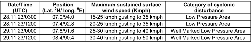
Bhubaneswar: The India Meteorological Department (IMD) on Tuesday informed that the low pressure over South Andaman Sea is likely to move west-northwestwards and intensify into a depression over southeast Bay of Bengal around November 30.
“Thereafter, it is likely to move northwestwards and intensify further into a cyclonic storm over southwest & adjoining southeast Bay of Bengal during subsequent 48 hours,” it added.
The exact path of the system will be known once it intensifies into a depression, director at Bhubaneswar Meteorological Centre H R Biswas said.
Odisha is likely to experience four-day dry spell after light to moderate rain/thundershower may occur at one or two places over the districts of Koraput, Nabarangpur, Kalahandi, Nuapada, Bolangir, Bargarh, Jharsuguda, Sundargarh, Keonjhar and Mayurbhanj on Tuesday. Light to moderate rain/thundershower will resume at one or two placesin Koraput, Rayagada, Gajapati, Ganjam, Puri and Jagatsinghpur on December 3. There is also a forecast for light to moderate rain/ thundershower at one or two places over the districts of Malkangiri, Koraput, Rayagada, Gajapati, Ganjam, Kandhamal, Puri, Khurda, Jagatsinghpur, Kendrapada, Bhadrak and Balasore on December 4. However, the weather agency is yet to issue any warning for the state due to the system brewing in the Bay of Bengal.
However, under the influence of anticipated system, squally wind speed reaching 40 to 50 kmph gusting to 60 kmph is likely over central Bay of Bengal adjoining to southwest Bay of Bengal from December 1 and it is likely to become 50 to 60 kmph gusting to 70 kmph the following day. As sea conditions are likely to be rough to very rough, fishermen have been advised not to venture into deep sea areas of central Bay of Bengal from December 1.
According to Tropical Weather Outlook issued by IMD on Tuesday, the weather models are indicating delayed formation of
depression. “There is large variation among various models on date of formation of depression, varying between November 30 and December 2. However, most of the models are indicating initial westnorthwestwards movement, followed by north-northwestwards movement. Some of the models are also indicating northeastwards recurvature. There is consensus among various models on intensification into cyclonic storm and higher intensity storm,” it said.
PRE-GENESIS TRACK & INTENSITY FORECASTS
IMD GFS is indicating extended low pressure area over southeast bay of bengal on November 28, depression on December 1 with rapid intensification into a very severe cyclonic storm on December 3 over the same region. It is indicating further intensification. It is indicating initial west-northwestwards movement followed by north-northwestwards movement and crossing over north Andhra Pradesh-South Odisha coasts on December 5.
ECMWF is indicating formation of depression on December 1 over southeast Bay of Bengal. It is also indicating intensification into cyclonic storm on December 3 over the same region and further intensification into very severe cyclonic storm. It is indicating crossing over north Andhra Pradesh-South Odisha coasts on Decdember 5 near Kakinada as an intense cyclone.
NCUM is indicating formation of low pressure area on December 1 over southeast Bay of Bengal with west-northwestwards movement and depression over the same region on December 2. It is also suggesting further intensification into a cyclonic storm on December 4.
IMD Multi Model Ensemble (MME) is indicating formation of depression around November 30. Thereafter, the system is indicated to intensify into a cyclonic storm on December 2 over southeast Bay of Bengal. Model is indicating intensification
up to severe cyclonic storm stage and rapid weakening before landfall. Landfall is indicated over North Andhra Pradesh-South Odisha coasts on December 5 as a cyclonic storm.
If the system intensify into a cyclone, it will be called Michaung, a name suggested by Myanmar. It will be the sixth such event forming in the Indian Ocean this year, compared to the customary four cyclones that occur in most years, and the fourth in the Bay of Bengal.


