Depression Forms Over Bay Of Bengal, Another Cyclonic Circulation Likely Around Sept 17

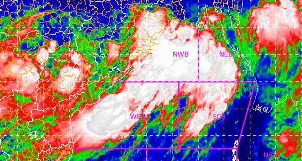
Bhubaneswar: The well-marked low-pressure area over west-central and adjoining north-west Bay of Bengal off north Andhra Pradesh and south Odisha coasts has intensified into a depression, the India Meteorological Department (IMD)’s regional centre informed on Sunday.
ଦକ୍ଷିଣ ଓଡିଶା ଏବଂ ପାର୍ଶ୍ୱବର୍ତ୍ତୀ ଅଞ୍ଚଳରେ ସୁଦୃଶଲଘୁଚାପ କ୍ଷେତ୍ର ଘନୀଭୂତ ହୋଇ ଅବପାତ ରେ ପରିଣତ pic.twitter.com/NjNFSof98p
— Meteorological Centre, Bhubaneswar (@mcbbsr) September 11, 2022
The system is about 20km northwest of Gopalpur and is likely to move west-northwestwards across south Odisha and south Chhattisgarh during next 24 hours and weaken gradually, added MeT.
An orange warning for heavy to very heavy rainfall has been issued in Nabarangpur, Kalahandi, Kandhamal, Nuapada, Balangir, Sonepur, Boudh and Bargarh districts till 8.30 am of September 12.
Likewise, a yellow warning has been sounded for Khurda, Cuttack, Sambalpur, Jharsuguda, Angul, Dhenkanal, Ganjam, Nayagarh, Mayurbhanj, Keonjhar, Sundargarh, Rayagada, Koraput, Gajapati, Deogarh and Puri districts.
Squally weather with surface wind speed reaching up to 45 to 55 kmph gusting to 65 kmph is very likely over the sea along and off Odisha coast and north-west adjoining west-central Bay of Bengal till September 12, a bulletin issued by IMD said.
The rainfall intensity is likely to decrease from September 12. However, a few places in interior Odisha and districts adjoining Chhattisgarh may witness spells of rain.
Meanwhile, IMD DG Mrutyunjay Mohapatra said that Odisha is likely to witness more rainfall activities as a fresh cyclonic circulation is likely to brew over the Bay of Bengal around September 17-18.
“As per the September forecast, low pressure systems might bring good rainfall in Odisha every week throughout the month and that is what has happened so far,” Mohapatra told mediapersons on Saturday.

Comments are closed.