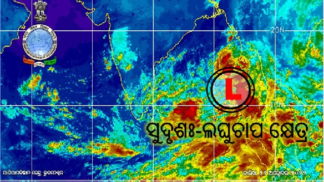
Depression Likely To Form Over Bay Of Bengal In 12 Hours

Bhubaneswar: The low-pressure area over the north Andaman sea and adjoining areas of the south Andaman Sea and Southeast Bay of Bengal now lies as a well-marked low-pressure area, the regional centre of India Meteorological Department (IMD) informed on Saturday.
The system is likely to concentrate into a depression during the next 12 hours and then move northwestwards intensifying further into a deep depression over the east-central and adjoining southeast Bay of Bengal on Sunday.
ଆଗାମୀ #୧୨ଘଣ୍ଟା ମଧ୍ୟରେ #ଅବପାତ!!
ସୁଦୃଶଃ ଲଘୁଚାପ କ୍ଷେତ୍ର ଦକ୍ଷିଣ-ପୂର୍ବ ପାର୍ଶ୍ଵବର୍ତ୍ତୀ ପୂର୍ବ-କେନ୍ଦ୍ରୀୟ ବଙ୍ଗୋପସାଗର ଅଞ୍ଚଳରେ ସକ୍ରିୟ, ଏହା ଉତ୍ତରପଶ୍ଚିମ ଦିଗରେ ଗତିକରି ପୂର୍ବକେନ୍ଦ୍ରୀୟ ପାର୍ଶ୍ଵବର୍ତ୍ତୀ ଦକ୍ଷିଣ-ପୂର୍ବ ବଙ୍ଗୋପସାଗର ଅଞ୍ଚଳରେ ଆଗାମୀ ୧୨ଘଣ୍ଟା ମଧ୍ୟରେ ଅବପାତରେ ପରିଣତ ହେବା ସମ୍ଭାବନା ରହିଛି pic.twitter.com/96Q5B7Fyru— Meteorological Centre, Bhubaneswar (@mcbbsr) October 22, 2022
“Subsequently, it is very likely to recurve gradually northwards and intensify into a cyclonic storm over the west-central and adjoining east-central Bay of Bengal by October 24. Thereafter, it is likely to move north-northeastwards and reach near West Bengal-Bangladesh coasts on October 25, skirting Odisha coast,” IMD said in a special weather bulletin.
It is likely to make landfall as a severe cyclonic storm on October 25 evening and attain a maximum sustained surface wind speed of 90-100 kmph gusting to 110 kmph.
Notably, Special Relief Commissioner (SRC) Pradeep Jena could pass along the Odisha coast 200 km from Dhamra Coast.
Citing the India Meteorological Department (IMD) track forecast report, he further said that Jagatsinghpur, Bhadrak, and Balasore districts could experience a maximum wind speed of 50-60 km. Though the cyclone will skirt Odisha’s coast, it is likely to trigger heavy rain in Odisha from Monday onwards. “Very heavy rain is likely in some coastal districts of the state on October 24,” he said.
Also Read: ‘Sitrang’ To Make Landfall As Severe Cyclonic Storm; Check Track & Wind Warning For Odisha

Comments are closed.