Bhubaneswar:A fresh low-pressure area has formed over Northwest Bay of Bengal and adjoining West Bengal and Bangladesh coasts, the India Meteorological department (IMD) informed on Sunday.
“Under the influence of the upper air cyclonic circulation over southwest Bangladesh and Gangetic West Bengal, another low-pressure area formed over Northwest Bay of Bengal and adjoining West Bengal and Bangladesh coasts at 5.30 am on June 29.”
The system is likely to move slowly westnorthwestwards across North Odisha, Gangetic West Bengal & Jharkhand during the next 2 days.
The weather agency has forecast isolated heavy rainfall in Odisha from June 29 to July 4. Some places in the state may also witness very heavy rainfall till July 1. Light/moderate rainfall accompanied by thunderstorm, lightning & gusty winds speed reaching 30-40 kmph may occur at most/many places in the state on June 29.
“The low pressure is likely to trigger very heavy rains in parts of Odisha between Sunday and Tuesday. As the southwest monsoon is active over the state, heavy rainfall activity is expected to prevail next week,” said Director of Bhubaneswar Meteorological Centre Manorama Mohanty.
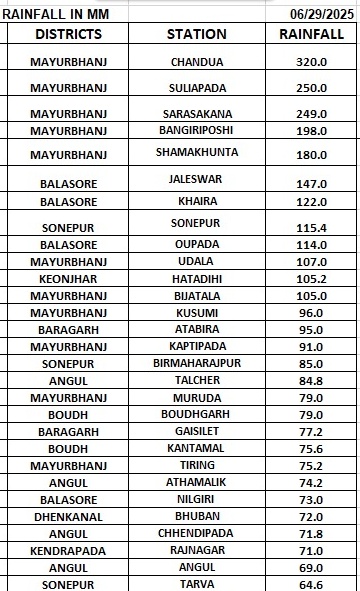
There is a warning for very heavy rain in Mayurbhanj district and heavy showers in Balasore and Bhadrak on Sunday. Very heavy rain may continue in Mayurbhanj, Keonjhar and Sundargarh districts on Monday and in Nayagarh, Kalahandi and Kandhamal districts on Tuesday, according to the MeT office.
Notably, widespread rainfall has been recorded in the state under the influence of a cyclonic circulation and low pressure. Some places in Mayurbhanj district have seen heavy to very heavy rainfall (7 to 20 cm), while there has been extremely heavy rain (20 to 30 cm) at 2 places and exceptionally heavy heavy (>30 cm) rainfall at one place.


