Bhubaneswar: Even as Odisha sounded an alert for the next 48 hours when the flood situation is likely to peak, the India Meteorological Department on Wednesday warned about an increase in rainfall activity in the state from August 18 with the anticipated fresh low pressure over the Bay of Bengal.
“Yesterday’s depression is likely to continue to move westnorthwestwards and weaken gradually to a well-marked low-pressure area during the next 12 hours,” the MeT office said in its midday bulletin.
A low-pressure area is likely to form over north Bay of Bengal around August 19, it added.
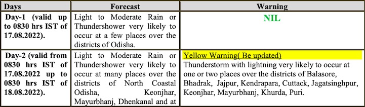
While light to moderate rain is likely at a few places in the state till 8.30 am on August 17, the IMD has issued yellow warning for thunderstorm with lightning for one or two places in Balasore, Bhadrak, Jajpur, Kendrapara, Cuttack, Jagatsinghpur, Keonjhar, Mayurbhanj, Khurda and Puri for the subsequent 24 hours.
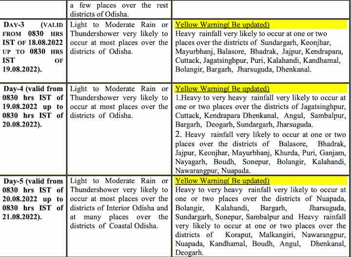
Heavy rainfall will resume from August 18 with yellow warning issued for one or two places in Sundargarh, Keonjhar, Mayurbhanj, Balasore, Bhadrak, Jajpur, Kendrapada, Cuttack, Jagatsinghpur, Puri, Kalahandi, Kandhamal, Balangir, Bargarh, Jharsuguda and Dhenkanal.
Odisha is likely to witness heavy to very heavy rainfall during the next two days, following which, there will be a decrease in rainfall activity, the IMD added.
Notably, Special Relief Commissioner PK Jena on Tuesday said the flood situation in Mahanadi will peak in the next 48 hours as Mundali barrage in Cuttack will see the highest floodwater outflow of 11.5 cusec in the evening. Flood impact is likely to be maximum in Puri, Kendrapada, Khurda and Jagatsinghpur districts due to heavy inflow of floodwater downstream of Mahanadi, he added.
Also Read: Odisha Flood: Next 48 Hours Crucial, 10 Dists on High Alert, Says SRC
