Bhubaneswar: Severe Cyclonic Storm ‘Hamoon’ over Northwest Bay of Bengal is likely to become Very Severe Cyclonic Storm, the India Meteorological Department (IMD) informed on Tuesday.
“Severe Cyclonic Storm Hamoon over Northwest Bay of Bengal moved northeastwards with a speed of 21 kmph and lay centered at 5.30 am over the same region, about 230 km east-southeast of Paradip(Odisha), 240 km south-southeast of Digha (West Bengal), 280 km south-southwest of Khepupara (Bangladesh),” the weather agency posted on X.
“It is very likely to intensify further into a very severe cyclonic storm for a few hours during next 6 hours. Thereafter, it is likely to weaken gradually while moving northeastwards and cross Bangladesh coast between Khepupara and Chittagong around evening of October 25 as a cyclonic storm with wind speed of 65 to 75 kmph gusting to 85 kmph,” it added.
Under its influence, light to moderate rainfall may occur at most places in coastal Odisha during next 24 hours.
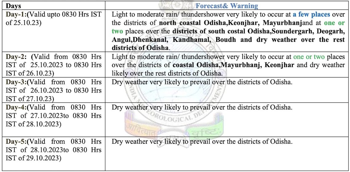
The IMD further informed that squally wind speed reaching 40-50 kmph gusting to 60 kmph is likely till October 24 and decrease thereafter. Sea conditions to remain rough to very rough till October 25. Fishermen have been advised not to venture into sea along and off Odisha coast and westcentral &North Bay of Bengal till October 25. Distant warning Signal No-2 (DW-2) has been hoisted at all ports of Odisha.


