Bhubaneswar: Intense thunderstorm activity with heavy rain and wind speed gusting to 80kmph is likely in seven districts of Odisha over 2 days, the India Meteorological Department (IMD) informed on Friday.
An orange warning of thunderstorm accompanied by lightning and gusty surface wind (60-70 kmph gusting to 80 kmph) & heavy rainfall has been issued for afternoon/evening hours at one or two places in the districts of Angul, Dhenkanal, Keonjhar, and Mayurbhanj on May 29.
Thunderstorm accompanied by lightning and gusty surface wind (50-60 kmph) may also occur in the afternoon/evening hours at one or two places in Balasore, Bhadrak, Jajpur, Kendrapada, Jagatsinghpur, Cuttack, Sundargarh, Sambalpur, Deogarh, Boudh, Kandhamal, Rayagada, Koraput, and Gajapati.
There is also a yellow warning of thunderstorm accompanied by lightning and gusty surface wind (40-50 kmph) very likely for the districts of Jharsuguda, Bargarh, Sonepur, Nuapada, Balangir, Kalahandi, Nabarangpur, Malkangiri, Ganjam, Puri, Khurda and Nayagarh.
Squally weather with wind speed reaching 40-50 kmph gusting to 60 kmph may also prevail along & off North Odisha Coast. Fishermen have been advised against venturing into the sea, which is likely to remain rough to very rough in this region.
On May
30, thunderstorm accompanied by lightning and gusty surface wind (60-70 kmph gusting to 80 kmph) & heavy rainfall may continue in Sundargarh, Jharsuguda and Sambalpur districts.
Thunderstorm accompanied by lightning and gusty surface wind (50-60 kmph) is also likely in the afternoon/evening hours at one or two places over the districts of Angul, Keonjhar, Mayurbhanj, Boudh, Nuapada, Balangir, Kalahandi, Kandhamal and Deogarh.
A yellow warning of thunderstorm accompanied by lightning and gusty surface wind (40-50 kmph) has also been issued for the districts of Balasore, Bhadrak, Jajpur, Kendrapada, Jagatsinghapur, Cuttack, Bargarh, Dhenkanal, Sonepur, Nabarangpur and Rayagada.
This is being attributed to a cyclonic circulation, which persists over north interior Odisha, and causing Kalbaisakhi showers in the afternoon/evening hours.
The IMD has issued an advisory for the districts of Angul, Dhenkanal, Keonjhar, Mayurbhanj, Balasore, Bhadrak, Jajpur, Kendrapada, Jagatsinghpur, Cuttack, Sundargarh, Sambalpur, Deogarh, Boudh, Kandhamal, Rayagada, Koraput, Jharsuguda, Gajapati, Nuapada, Balangir, and Kalahandi on these two days. Strong winds can damage horticulture and standing crops along with vulnerable structures in these districts. People have been advised to keep watch on weather and move to safer places during the thunderstorm activity to protect themselves from lightning. Also harvesting of crops may be regulated judicially and farmers are advised to use hail nets to protect vegetables and crops from hail, it added.
It has also predicted a fall in the day temperature by 2-4 degrees over the next 3 days.
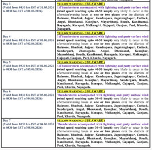
According to the midday bulletin, thunderstorm activity, though lower in intensity, may continue in the state till June 4. Hot and humid conditions may also prevail at isolated places in the districts of Balasore, Bhadrak, Jajpur, Kendrapada, Jagatsinghpur, Cuttack, Gajapati, Ganjam, Puri, Khurda and Nayagarh till June 2.