IMD Confirms Landfall Of Cyclone ‘Dana’ Along Odisha Coast; Check District-Wise Wind Warning

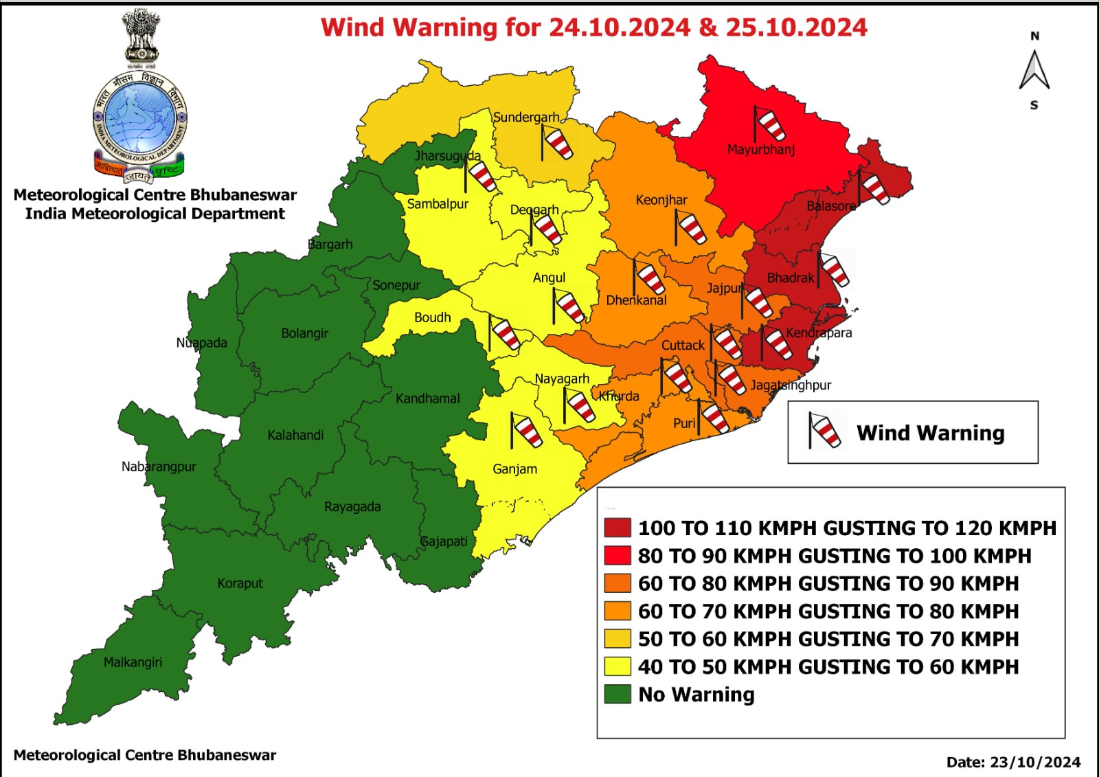
Bhubaneswar: Cyclone ‘Dana’ is likely to make landfall along Odisha coast close to Bhitarkanika and Dhamra by October 24-25 as a severe cyclonic storm with a wind speed of 100-110 kmph gusting 120 kmph, the India Meteorological Department (IMD) informed on Wednesday.
“The cyclonic storm over Eastcentral Bay of Bengal moved northwestwards with a speed of 15 kmph during past 6 hours and lay centred at 8.30 am over the same region, about 520 km southeast of Paradip (Odisha), 600 km south-southeast of Sagar Island (West Bengal) and 610 km south-southeast of Khepupara (Bangladesh). It is very likely to move northwestwards and intensify into a severe cyclonic storm over northwest Bay of Bengal by early morning of October 24 and cross north Odisha and West Bengal coasts between Puri and Sagar Island close to Bhitarkanika and Dhamra (Odisha) during night of October 24 to October 25 as a severe cyclonic storm with a wind speed of 100-110 kmph gusting 120 kmph.”
Storm surge of 1.0 to 2.0 m height above astronomical tide is also likely to inundate low-lying areas of Kendrapada, Bhadrak and Balasore districts at the time of landfall.
Also Read: Cyclone ‘Dana’: Extremely Heavy Rain, Gale@120kmph & Storm Surge Warnings For Odisha
The IMD has also warned of gale winds with speed of 100 to 110 kmph gusting to 120 kmph in Kendrapada, Bhadrak and Balasore districts on October 24-25. Squally weather with wind speed of 80 to 90 kmph gusting to 100 kmph may prevail in Mayurbhanj district, while Cuttack, Jagatsinghpur and Jajopur may experience wind speed of 60 to 80 kmph gusting to 90 kmph. The wind speed in Puri, Khurda, Dhenkanal and Keonjhar is likely to be 60 to 70 kmph gusting to 80 kmph.
Rain Warning
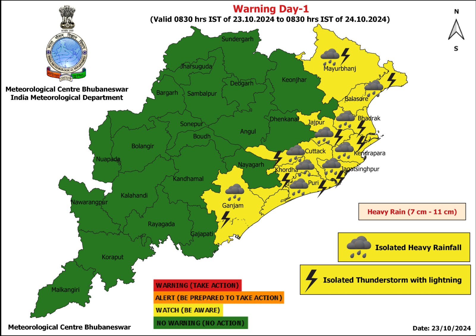
Yellow warning of heavy rainfall has been issued for Balasore, Bhadrak, Jagatsinghpur, Kendrapada, Puri, Jajpur, Cuttack, Khurda, Ganjam and Mayurbhanj on October 23
OCTOBER 24
Red warning (Take Action)
Scattered heavy to very heavy rainfall (7 to 20cm) with isolated extremely heavy rainfall (>20cm) falls may occur in Jagatsinghpur, Kendrapada, Cuttack, Bhadrak, Jajpur, Balasore, and Mayurbhanj districts.
Orange warning (Be Prepared to take action)
Heavy to very heavy rainfall (7 to 20cm) is likely at isolated places in Puri, Khurda, Keonjhar, Nayagarh and Dhenkanal.
Yellow Warning (Be Aware)
Heavy rainfall (7 to 11cm) may also occur at isolated places in Ganjam, Boudh, Angul, Deogarh, Sundargarh and Kandhamal.
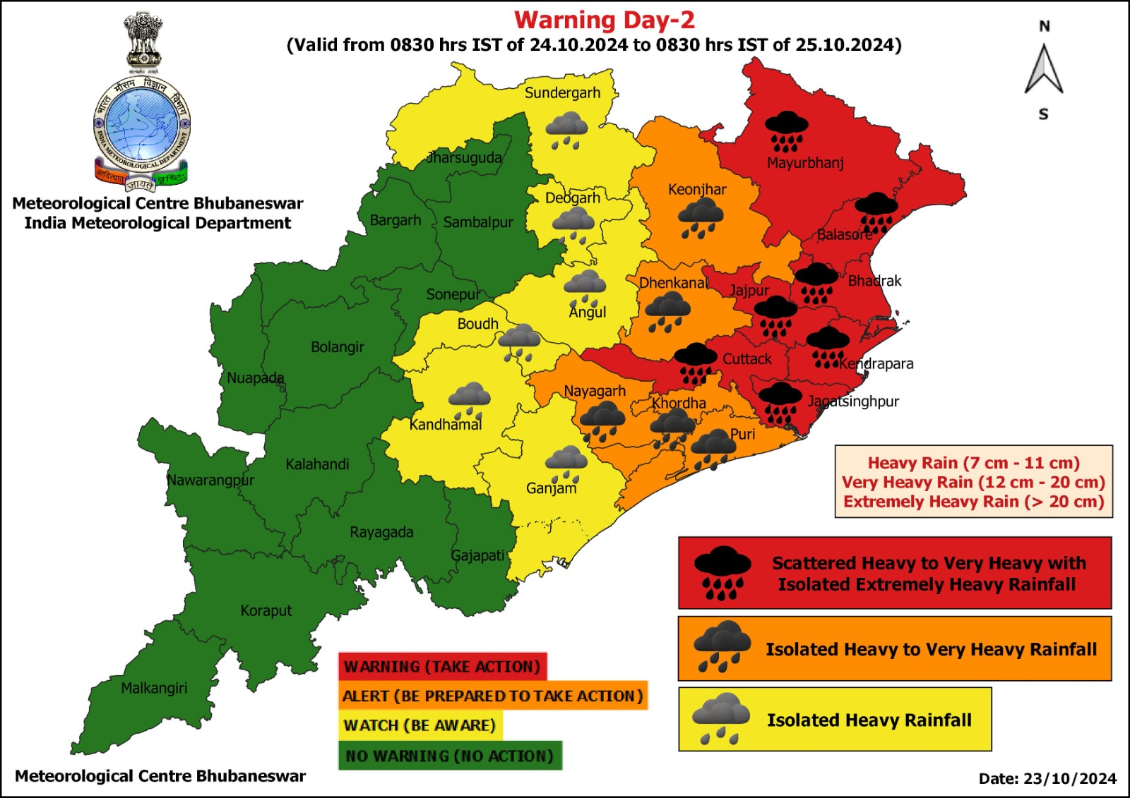
OCTOBER 25
Red warning (Take Action)
Scattered heavy to very heavy falls (7 to 20cm) with isolated extremely heavy rainfall (>20cm) may occur at isolated places in Mayurbhanj, Keonjhar, Balasore nd Bhadrak districts.
Orange warning (Be Prepared to take action)
Heavy to very heavy rainfall (7 to 20cm) is likely at isolated places in Jajpur, Kendrapada, Dhenkanal, Angul, Cuttack and Jagatsinghpur.
Yellow Warning (Be Aware)
Heavy rainfall (7 to 11cm) may also occur at isolated places in Sundargarh, Sambalpur, Deogarh, Khurda, Jharsuguda and Puri.
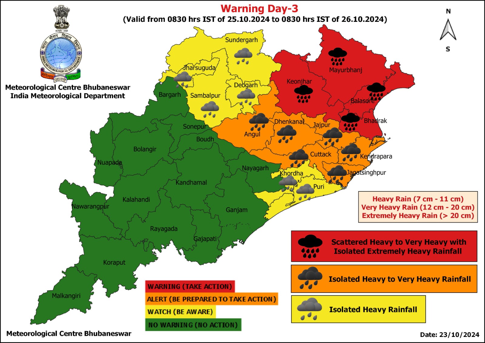
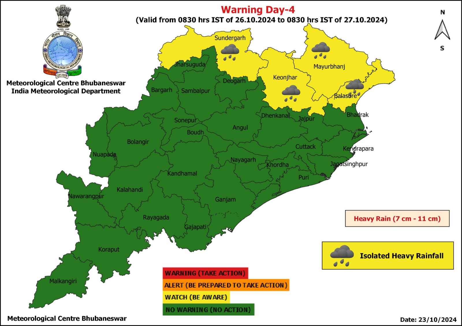
Heavy rainfall may continue at isolated places in Sundargarh, Keonjhar, Mayurbhanj and Balasore on October 26, according to the weather agency.
The MeT office has also warned of squally wind speed reaching 40-50 gusting to 60 kmph along and off Odisha coasts from October 23 evening. It would gradually increase becoming gale wind speed reaching 60-70 kmph gusting to 80 kmph from October 24 morning and reaching 100-110 kmph gusting to 120 kmph from October 24 night till October 25 morning and decrease gradually thereafter.