Bhubaneswar: With southwest monsoon active over Bay of Bengal, Odisha is likely to experience widespread rainfall, ranging between 7 cm and 11 cm, till June 24, the regional centre of India Meteorological Department (IMD) tweeted on Tuesday.
“Under the influence of southerly/southwesterly winds from the Bay of Bengal to Northeast and adjoining east India, isolated heavy rainfall is likely over Odisha during June 20-24,” the MeT office said.
Notably, monsoon has advanced into most parts of Madhya Pradesh, remaining parts of Chhattisgarh and coastal Andhra Pradesh, remaining parts of northwest Bay of Bengal, entire Odisha and Gangetic West Bengal, most parts of Jharkhand and Bihar, some parts of southeast Uttar Pradesh till June 20.
In the next 24 hours, heavy rainfall is likely at one or two places in Balasore, Bhadrak, Jajpur, Kendrapada, Cuttack, Jagatsinghpur, Dhenkanal, Angul, Khurda, Puri, Keonjhar, Mayurbhanj, Koraput and Malkangiri.
Yellow warning for thunderstorm with lightning has also been issued for one or two places in Balasore, Bhadrak, Jajpur, Kendrapada, Cuttack, Jagatsinghpur, Sundargarh, Jharsuguda, Bargarh, Sambalpur, Deogarh, Angul, Dhenkanal, Keonjhar, Mayurbhanj, Khurda, Puri, Nayagarh, Kandhamal and Ganjam.
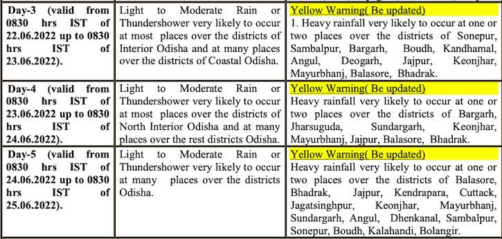
Check the forecast for the next subsequent 3 days:
Squally weather with wind speed of 40-50 kmph gusting to 60 kmph is also likely over Northwest Bay of Bengal along and off Odisha-West Bengal coasts till June 22. Fishermen have been advised not to venture into the sea.


