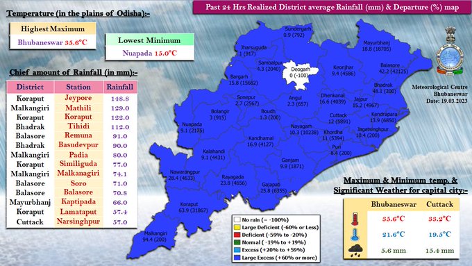
Bhubaneswar: Amid rain and thunderstorm activities, which helped bring down the mercury level in several parts of Odisha on Saturday, Bhubaneswar recorded the highest maximum temperature at 35.6 degre Celsius and Nuapada the lowest of 15 degree Celsius.
The state capital also witnessed showers in the evening and waterlogging was reported in a few parts. The maximum temperature in the city, however, is likely to drop to 28 degree Celsius following one or two spells of thundershower, the India Meteorological Department (IMD) said on Sunday.
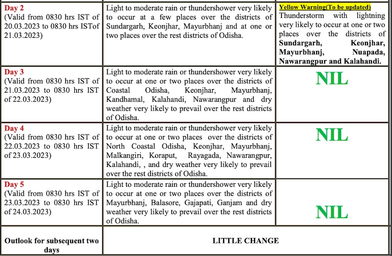
The IMD has also issued a nowcast warning for light to moderate rain and thunderstorm/lightning in Keonjhar, Mayurbhanj, Balasore, Jagatsinghpur, Cuttack, Kendrapada and Sundargarh during the next three hours. It has forecast thunderstorm with lightning and gusty surface wind reaching up to 50 kmph at one or two places in Sundargarh, Keonjhar, Mayurbhanj, Deogarh, Jajpur, Bhadrak, Balasore, Gajapati, Ganjam and Kandhamal during the next 24 hours. Thunderstorm with lightning may occur at one or two places in remaining districts of Odisha during this period.
Light to moderate rain or thundershower is also likely at many places in coastal Odisha, Mayurbhanj, Keonjhar, Dhenkanal, Angul, Sundargarh and at a few places in the rest of the state.
While yellow warning for thunderstorm/lightning continues for the subsequent 24 hours and Odisha is likely to experience rain till March 24 morning, the MeT office added that the maximum temperature may rise by 2-4 degree Celsius at many places in the state after 2 to 3 days.
FORECAST FOR NEXT 4 DAYS
In the last 24 hours, Jeypore in Koraput recorded the highest 148.8 mm rainfall followed Mathili in Malkangiri (129), Koraput (122) and Tihidi in Bhadrak (112), the MeT office said.
Check rainfall at other place here:


