Bhubaneswar: With the cold wave subsiding, the India Meteorological Department (IMD) on Tuesday forecast a gradual rise in night temperature by 2-3 degree Celsius during the next two to three days.
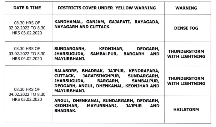
The MeT office has also issued yellow warning for three days from February 2. Dense fog very is likely to occur at one or two places in Kandhamal, Ganjam, Gajapati, Rayagada, Nayagarh and Cuttack till 8.30 am on February 3.
The state is also likely to experience rainfall activity under the influence of west disturbance. While light to moderate rain or thundershower is likely to occur at a few places in Sundargarh, Keonjhar, Deogarh, Jharsuguda, Sambalpur and Bargarh between 8.30 am on February 3 and 8.30 am on February 4, yellow warning for thunderstorm with lighting has been issued for one or two places in Sundargarh, Keonjhar, Deogarh, Jharsuguda, Sambalpur, Bargarh and Mayurbhanj.
Also Read: Western Disturbance To Impact Odisha, Hailstorm Alert; Hotter Days, Cooler Nights In February
Light to moderate rain or thundershower is very likely to occur at many places in North Odisha and a few places in South Odisha during the subsequent 24 hours. Alert has been issued as one or two places in Balasore, Bhadrak, Jajpur, Kendrapada, Cuttack, Jagatsinghpur, Sundargarh, Jharsuguda, Bargarh, Sambalpur, Deogarh, Angul, Dhenkanal, Keonjhar and Mayurbhanj are likely to experience thunderstorm and lightning.
Hailstorm is also likely to occur at one or two places in Angul, Dhenkanal, Sundargarh, Deogarh, Keonjhar, Mayurbhanj, Jajpur, Bhadrak and Balasore during this period.
The office of Special Relief Commissioner has directed police and transport officials to take steps to prevent accidents during dense fog. Farmers have been advised to cover their harvest crops and keep them in safe places.


