Bhubaneswar: Widespread light to moderate rainfall activity with isolated heavy to very heavy rainfall is likely in Odisha during next 3-4 days under the influence of a low pressure area, which has formed over Northwest Bay of Bengal off West Bengal-Odisha coasts, and an active Southwest Monsoon.
“The Monsoon Trough is now passing through Jaisalmer, Kota, Guna, Siddhi, Ranchi and the centre of low pressure area over Northwest Bay of Bengal off West Bengal-Odisha coasts and thence, southeastwards to Eastcentral Bay of Bengal. The low pressure system is likely to move west-northwestwards across North Odisha & South Jharkhand during next 2 days,” the India Meteorological Department (IMD) said in its midday bulletin.
Thunderstorm with lightning activity is also likely during the next 2 days.
The weather agency has issued orange warning of heavy to very heavy rainfall (7 to 20cm) for one or two places in Keonjhar, Mayurbhanj, Balasore, Bhadrak, Kendrapada, Jagatsinghpur, and Puri till 8.30 am on Wednesday.
Heavy Rainfall (7 to 11cm) may also occur at one or two places in Jajpur, Cuttack, Khurda, Ganjam, Dhenkanal, Angul, Deogarh, Sundargarh, Jharsuguda, Sambalpur, Sonpur, Boudh, Kandhamal, and Kalahandi. Yellow warning of thunderstorm with lightning has also been sounded for Balasore, Bhadrak, Jajpur, Kendrapada, Jagatsinghpur, Cuttack, Khurda, Puri, Nayagarh, Ganjam, Gajapati, Mayurbhanj, Keonjhar, Angul, Dhenkanal, Sambalpur, Sundargarh, Deogarh, Jharsuguda, Bargarh, Boudh, Kalahandi, Kandhmal, Sonepur and Balangir.
Also Read: Low Pressure Forms Over Bay Off Odisha-Bengal Coasts; Check Its Movement & Rain Forecast
The MeT office has also warned of waterlogging in low-lying areas and underpasses, inundation of agriculture field, some damage to kutcha roads and houses, landslides/mudslides in vulnerable hilly areas and occasional reduction of visibility, leading to traffic jams, in urban areas during intense spells of rain, which may also lead to the rise in the water level of rivers in the state.
Farmers have been advised to postpone fertilizer/chemicals application in agricultural field and keep livestock at safe places.
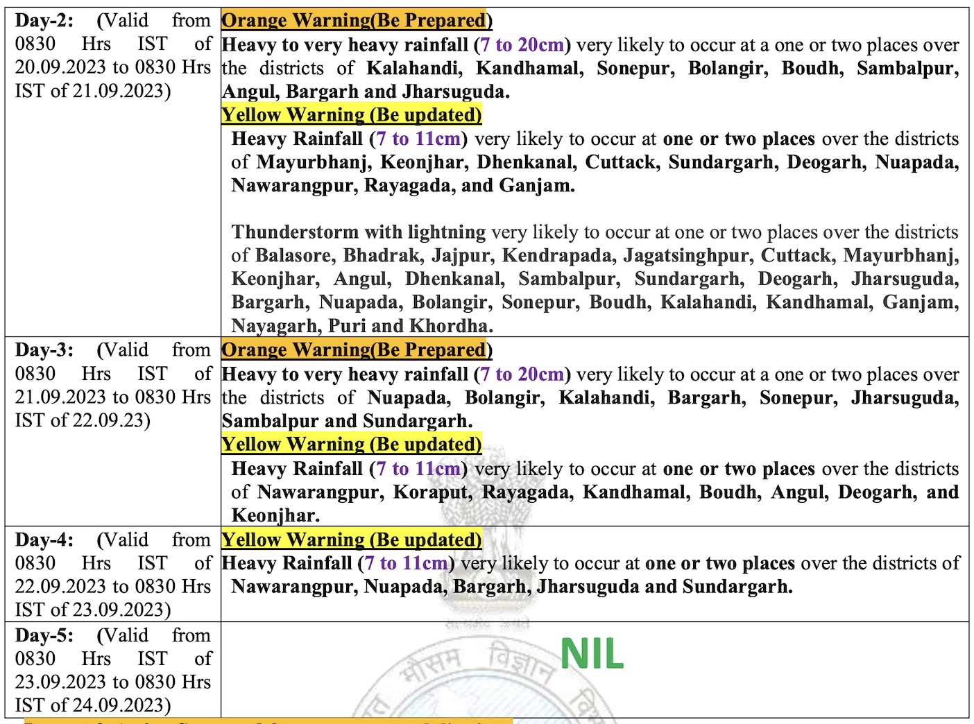
CHECK FORECAST FOR NEXT 4 DAYS
According to SOA’s Centre for Environment and Climate (CEC), moderate to heavy rainfall may occur at most places of coastal, north and west Odisha on September 19 and 20 under the influence of the circulation and the low pressure area. The system is expected to shift to neighbouring Chhattisgarh from September 20 night, the bulletin added.
Two wet spells have helped reduce the rain deficit in Odisha, which has recorded 1017.6 mm rainfall against the of 1084.2 mm till September 18 this monsoon season. While two districts have received excess rain and 24 are in normal category, only four have recorded a shortfall.


