
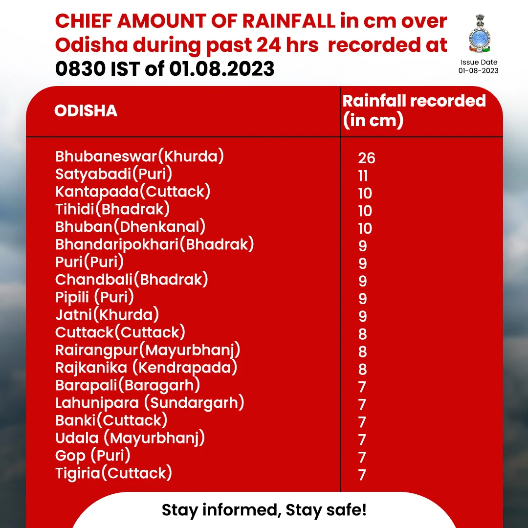
Bhubaneswar: With intense spells of rain lashing Bhubaneswar since Monday afternoon, the India Meteorological Department on Tuesday informed that the city had received the highest August rainfall since 1952.
The city recorded 259.2 mm rainfall in the past 24 hours. “This is the highest one-day rainfall recorded in the month, breaking the previous record of 254.2mm on August 20, 1997… Since 1952,” it tweeted.
Bhubaneswar had recorded 186 mm rainfall by 5.30 pm on Monday and it touched 258mm by 8.30 pm with the weather agency terming it as one of the most intense spells of rain in the city this monsoon season.
According to the MeT office, the state received significant rainfall in the last 24 hours with Bhubaneswar, Puri, Cuttack, topping the list. Roads in the state capital turned into streams and water entered many houses as rains pounded the city the previous day. Rain also played havoc in Cuttack and Puri, which saw flooding in several areas.
With the depression over Northeast Bay of Bengal intensifying into deep depression, the IMD now issued red warning of extremely heavy rain for two days in Odisha.
Also Read: Deep Depression Over Bay: Odisha Placed Under Red Alert, Extremely Heavy Rain Predicted
Heavy to very heavy rain (7 to 20 cm) with isolated extremely heavy falls (< 20cm) is likely at a few places in Angul, Keonjhar, Mayurbhanj and Dhenkanal districts till 8.30 am on Wednesday. Heavy to very heavy rainfall may also occur at a few places in Jajpur, Bhadrak, Deogarh, Sambalpur, Sonepur. Boudh, Sundargarh, Jagatsinghpur, Kendrapada, Puri, Cuttack, Khurda and Balasore. Heavy rainfall is also expected at one or two places in Kendrapada, Jagatsinghpuir, Bargarh, Jharsuguda, Nayagarh, Khurda, Puri, Kandhamal, Kalahandi, Balangir, Nuapada and Ganjam.
On August 2, there is a forecast for heavy to very heavy rainfall with isolated extremely heavy falls at a few places in Sundargarh, Jharsuguda, Bargarh, Balangir and Sambalpur. Heavy to very heavy rainfall is also likely at one or two places in Deogarh, Angul, Keonjhar, Sonepur, Boudh, Balangir, Nuapada, Kalahandi and Kandhamal. Very heavy rain may occur at one or two places in Mayurbhanj, Balasore, Dhenkanal, Cuttack, Nayagarh, Nabarangpur, Jajpur and Bhadrak, it added.
The IMD has warned of waterlogging in low-lying areas, landslides in hilly regions, some damage to kutcha roads and houses and waterlogging at underpass and occasional reduction in visibility causing traffic jams in urban areas. The intense spells of rain may also lead to significant rise in the water level of rivers in the state, it added.
The weather agency further said that squally weather with wind speed reaching 50 to 60 kmph is very likely along and off Odisha coast and north Bay of Bengal and adjoining westcentral Bay of Bengal till August 3 under the influence of the deep depression over Bay of Bengal and warned fishermen against venturing into the sea during this period.
Also Read: JTWC Issues Cyclone Alert In Bay; Deep Depression To Cross Bangladesh This Evening, Says IMD
Comments are closed.