Bhubaneswar: The twin cities of Cuttack and Bhubaneswar experienced its first heavy rainfall this season triggered by nor’wester on Saturday night.
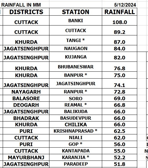
Cuttcak recorded 89.2mm rainfall followed by Bhubaneswar at 76.8mm. The state also witnessed a sudden drop in the temperature by 8.3 degree Celsius. “Sudden fall in temperature almost by 8.3°C. Gusty wind reported by 61 kmph in Bhubaneswar city area due to severe thunderstorm activities,” weather scientist of Bhubaneswar Meteorological Centre Uma Shankar Dash posted on X.
Significant rainfall across the state during past 24 hours due to Kalbaisakhi activity in coastal Odisha.
Heavy rain accompanied by thunderstorm, lightning and gusty wind lashed the twin cities of Bhubaneswar and Cuttack, leading to flooding in multiple areas. There was power cut in almost all parts of the cities.
“Summer nights in Bhubaneswar: where rain, wind, and lightning choreograph a mesmerizing dance. #StormySkies #MidnightMagic@NewIndianXpress@XpressOdisha @Agragami @Siba_TNIE pic.twitter.com/j247F7CwUI
— SHIBA (@shibasahu2012) May 11, 2024
While thunderstorm activity is expected to continue in Odisha till May 15, isolated heavy rainfall may also occur at some places till May 13.
The Met office has issued yellow warning of thunderstorm with lightning accompanied by gusty surface wind speed reaching 40-50 kmph for at one or two places in Kandhamal, Boudh, Angul, Dhenkanal, Keonjhar, Mayurbhanj, Balasore, Bhadrak, Jajpur, and Cuttack on Sunday.
Heavy rainfall may also occur at one or two places in Mayurbhanj, Balasore, Bhadrak, and Jajpur.
Thunderstorm with lightning accompanied by gusty surface wind speed reaching 30-40 kmph is also likely at one or two places in Sundargarh, Deogarh, Sambalpur, Khurda, Kendrapara, Jagatsinghpur, Kandhamal, Puri, Nayagarh, Ganjam till 8.30 am on Monday.


