Bhubaneswar: The India Meteorological Department (IMD) on Wednesday issued a weather forecast stating that a cyclonic storm is likely form over the southwest and adjoining southeast Bay of Bengal around December 2.
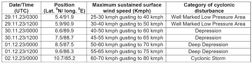
“Yesterday’s low-pressure area over south Andaman Sea and adjoining southeast Bay of Bengal moved westnorthwestwards and lay as a well-marked low pressure area over southeast Bay of Bengal & adjoining south Andaman Sea at 8.30 am. It is likely to move west-northwestwards and intensify into a depression over southeast Bay of Bengal on November 30. Thereafter, it is likely to move northwestwards and intensify gradually into a cyclonic Storm over southwest and adjoining southeast Bay of Bengal around December 2,” the MeT office said in a special bulletin.
If the system intensify into a cyclone, it will be called Michaung, a name suggested by Myanmar. It will be the sixth such event forming in the Indian Ocean this year, compared to the customary four cyclones that occur in most years, and the fourth in the Bay of Bengal.
The weather agency further said that there no weather or fishermen warnings for Odisha during the next 5 days.
RAIN FORECAST
However, light to moderate rain/thundershower may resume at one or two places in south coastal Odisha, Jagatsinghpur, Malkangiri, Koraput, Rayagada and Kandhamal on December 3, after a brief dry spell.
Light to moderate rain thundershower is also likely at a few places in Gajapati, Ganjam, Puri, Rayagada, Malkangiri, Koraput and at one or two places in Nabarangpur, Kalahandi, Kandhamal and rest districts of coastal Odisha on December 4.
Light to moderate rain/thundershower may occur at many places in Malkangiri, Koraput, Rayagada, Gajapati, Ganjam, Puri and at a few places in Nabarangpur, Kalahandi, Kandhamal, rest districts of coastal Odisha and at one or two places in remaining districts of the state on December 5.
WIND WARNING
However, under the influence of above system, squally wind speed reaching 35 to 45 kmph gusting to 55 kmph is likely over central Bay of Bengal adjoining to southwest Bay of Bengal from December 1 evening and is likely to become 45 to 55kmph gusting to 65 kmph on December 2 morning . Sea conditions are likely to be rough to very rough on December 1 and becoming very rough to high from December 2 morning. Fishermen have been advised not to venture into deep sea areas of central Bay of Bengal from December 1. Those out at sea have also advised to return to coast by December 1.
SRC ISSUES ALERT
Besides advising fishermen against venturing into the sea from December 1, office of Special Relief Commissioner, Odisha, has also directed the Agriculture department to take preventive measure for protection of paddy and other crops in the state in view of the forecasted cyclone and possible rain.
WEATHER MODELS PREDICTION
In its Tropical Weather Outlook issued on November 29, the IMD said that there is large variation among the forecast models on formation of depression with the date varying between November 30 and December 2. However, most of the models are indicating initial westnorthwestwards movement, followed by northwestwards movement. Models are also indicating northeastwards recurvature of the system. However, there is variation among various models on point and time of recurvature. There is consensus among various models about intensification of the system into cyclonic storm or higher intensity storm.
Pre-genesis track and intensity forecast
IMG GFS is indicating low-pressure area over southeast Bay of Bengal on November 29, depression on December 1 and rapid intensification into a very severe cyclonic storm on December 3 over the same region. It is indicating initial west-northwestwards movement, followed by northwestwards movement and crossing over Andhra Pradesh coast on December 5.
ECMWF is indicating formation of depression on December 2 over southwest Bay of Bengal and cyclonic storm on December 3
over the same region. It is indicating crossing over south Andhra Pradesh coast on December 4 as a depression.
NCUM is indicating formation of depression on December 2 over southwest Bay of Bengal. It is also suggesting further intensification into a cyclonic storm on December 4 over westcentral & adjoining southwest Bay of Bengal. Further intensification is also suggested till December 5 with weakening from December 7 onwards over northwest Bay of Bengal. It is indicating the system to recurve northeastwards and reach Bangladesh coast on December 8.
IMD Multi Model Ensemble (MME) is indicating formation of depression around November 30. Thereafter, the system is indicated to intensify into a cyclonic storm on December 3 over southwestBay of Bengal. Model is indicating peak intensification up to severe cyclonic storm stage. It is indicating likely northeastwards recurvature thereafter along the coast of North Andhra-Pradesh and south Odisha. It is further indicating that the system may emerge into northwest Bay of Bengal on December 7 and move towards Bangladesh coast as a weaker system.
Considering all the weather models, the IMD concluded that the well marked low-pressure area over southeast Bay of Bengal and adjoining Andaman sea is likely to move westnorthwestwards and intensify into a depression over southeast Bay of Bengal on November 30. Thereafter, it is likely to move northwestwards and intensify gradually into a cyclonic storm.


