Cyclone ‘Sitrang’ Likely To Gain Windspeed Of 110 Kmph; 5 Odisha Dists On Orange Alert
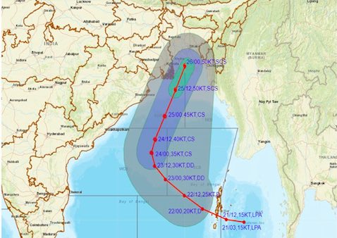
Bhubaneswar: The anticipated Cyclone ‘Sitrang’, which is brewing over Bay of Bengal, may attain a maximum sustained surface wind speed of 90-100 kmph gusting to 110 kmph and make landfall as a severe cyclonic storm on the evening of October 25 evening, the India Meteorological Department (IMD) informed on Friday.

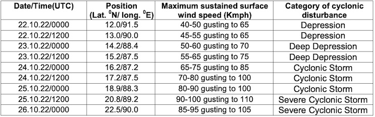
According to the MeT office, the probability of cyclogenesis (formation of depression) is very high in the next 24-48 hours. The low-pressure area over the north Andaman Sea and its neighbourhood is expected to move west northwestwards and concentrate into a depression over the east-central and adjoining the southeast Bay of Bengal around October 22 and into a deep depression the following day. The system is likely to intensify into a cyclonic storm over westcentral and adjoining eastcentral Bay of Bengal by October 24. Thereafter, it is expected to move north-northeastwards and reach near West Bengal-Bangladesh coasts on October 25, skirting Odisha coast, it said.
Also Read: 10 Cyclones In Last 2 Decades: Sitrang 3rd Consecutive Storm To Spare Odisha
Most weather models have made similar predictions, it added.
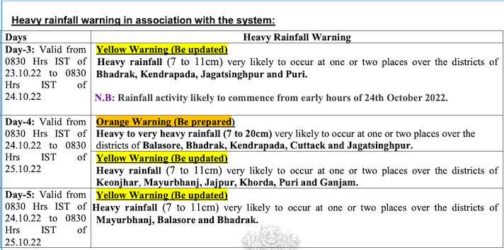
The post-monsoon cyclone is likely to trigger heavy rain in Odisha. Warnings have been issued for Puri, Jagatsinghpur, Kendrapara, Bhadrak, Balasore, Mayurbhanj, Jajpur, Keonjhar, Cuttack and Khurda districts.
Under the influence of the system, squally wind with speed reaching 35-45 kmph gusting to 55 kmph is likely on October 23, 45-55 kmph gusting to 65 kmph on October 24 and 50-60 kmph gusting to 70 kmph on October 25 along and off Odisha coast. Fishermen have been advised not to venture into deep sea area of central Bay of Bengal from October 22 and along and off Odisha coast and westcentral and North Bay of Bengal from October 23 to 26.
Comments are closed.