Bhubaneswar: As the low pressure area is active over north Odisha and adjoining areas on Monday, heavy to very heavy rain is likely to pound most parts of the state till Tuesday, according to the India Meteorological Department (IMD).
Under the influence of the low pressure area, another 24 hours of widespread rainfall is likely to occur across the state with heavy to very heavy rain in some districts of western and interior Odisha, said the Meteorological Centre in Bhubaneswar said.
The low pressure area is likely to cross Jharkhand and north Chhattisgarh to north Madhya Pradesh in the next two days, it said.
The Met Centre has issued orange alert for heavy to very heavy rain (6 cm to 20 cm) in eight districts and yellow warning for heavy rain (6 to 11 cm) in ten districts of the state on Monday.
While the orange alert has been issued for Bolangir, Bargarh, Sonepur, Sambalpur, Kalahandi, Boudh, Nabarangpur, and Nuapada districts, yellow warning has been sounded for Angul, Cuttack, Deogarh, Sundargarh, Malkangiri, Rayagada, Kandhamal, Dhenkanal, Jajpur, and Keonjhar districts.
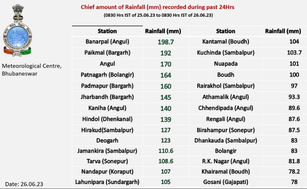
With almost entire Odisha receiving rainfall of varied intensity, highest rainfall of 198.7 mm was recorded at Banarpal in Angul district since Sunday morning. Paikmal in Bargarh district followed closely recording 192 mm rainfall between 8.30 am of Sunday and 8.30 am of Monday, while Angul received 170 mm rainfall.


