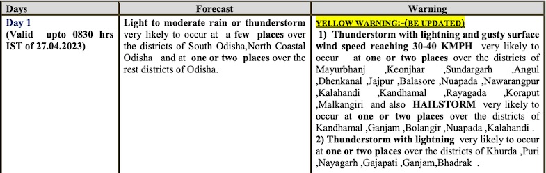
Bhubaneswar: Odisha is likely to experience thunderstorm with lightning and gusty surface wind speed reaching 30-40 kmph for 2 days, the India Meteorological Department informed on Wednesday.
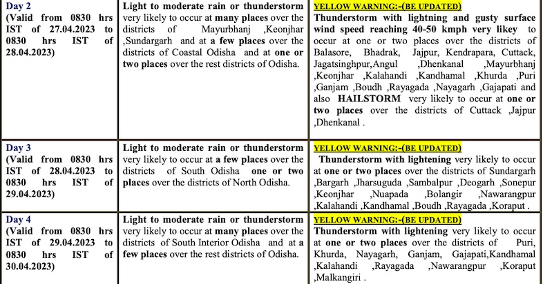
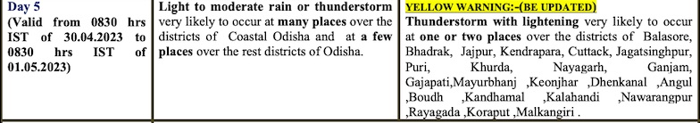
Hailstorm is also likely at one or two places in Kandhamal, Ganjam, Balangir, Nuapada and Kalahandi till 8.30 am on Thursday and in Cuttack, Jajpur and Dhenkanal districts during the subsequent 24 hours. Thunderstorm activity with lightning will continue for another 3 days along with light to moderate rain, the MeT office said.
CHECK THE FORECAST FOR NEXT 5 DAYS
The IMD further said that there will be no large change in the day temperature for the next 4-5 days.
Siksha ‘O’ Anusandhan (SOA)’s Centre of Environment and Climate (CEC) here had also said that day temperature is unlikely to rise in Odisha till May 5 due to incursion of moisture-laden wind from the Bay of Bengal caused by anti-cyclonic flow along the Andhra Pradesh and Odisha coast.
This anti-cyclonic flow has become favourable for availability of moisture over Odisha while local surface heating could cause sporadic nor’wester, also known as ‘Kalbaisakhi’ events, a CEC bulletin said, adding that day to day frequency of such events will be more in coastal and south Odisha districts.
“The day temperature is expected to hover around 35 or 36 degrees Celsius on most days baring four days between May 27 and 30 when the mercury could rise up to 38 degrees Celsius at few places in Odisha,” the bulletin further said.
The frequency of ‘Kalbaisakhi’ is likely to intensify from May 1 due to combination of upper air trough from the west and increased flow of moisture from the Bay of Bengal, it added.


